Methow, Washington facts for kids
Quick facts for kids
Methow, Washington
|
|
|---|---|

Methow, Washington
|
|
| Country | United States |
| State | Washington |
| County | Okanogan |
| Elevation | 1,154 ft (352 m) |
| Population
(2020)
|
|
| • Total | 246 |
| ZIP Code 98834 | |
| Time zone | UTC-8 (Pacific (PST)) |
| • Summer (DST) | UTC-7 (PDT) |
| ZIP code |
98834
|
| Area code(s) | 509 |
| FIPS code | 53-53720 |
| GNIS feature ID | 1523030 |
Methow is a small community in Okanogan County, Washington, United States. It is not officially a city or town, but an "unincorporated community." This means it doesn't have its own local government like a city does. In 2020, about 246 people lived there.
History of Methow
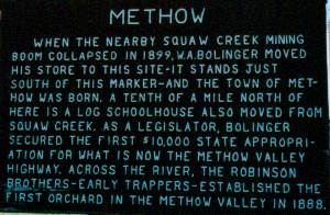
Methow was started in 1889 by W.A. Bolinger. He moved his store from a nearby mining town called Squaw Creek. The community gets its name from the Methow people. They were an Interior Salish group who lived in this area for a long time. The word "Methow" comes from the Okanagan language. It means "sunflower (seeds)."
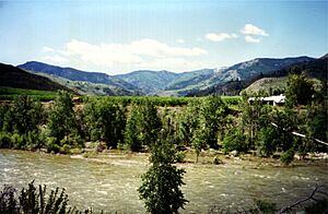
Today, Methow has its own community center. It also has a post office, a fire station, a church, and a water system. There are two parks for people to enjoy. The original Methow Store, built by W.A. Bolinger, was closed for many years. But it reopened in 2024! The town's restaurant is currently closed. Methow is a popular spot for people who want to go rafting on the Methow River.
You can see the old Methow Store right off Washington State Route 153. Across the street is a large historic stone house. The Bolinger family built this house a long time ago. Methow also has two old one-room schoolhouses. One of them is north of the Methow Store. Many people call it "the old log cabin." The other schoolhouse is now used as the community center. The Methow Church was started over 100 years ago.
The number of people living right in Methow has stayed about the same for decades. It's usually around fifty people. However, the population in the larger area, called the Methow Valley, has grown a lot in the last twenty years.
Geography of Methow
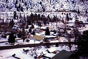
Methow is located on the Methow River. It's about 13 miles (21 km) upstream from where the Methow River joins the Columbia River. This area is in Okanogan County, Washington. Methow sits at an elevation of 1,156 feet (352 meters) above sea level. It is in the foothills of the Cascade Range mountains.
Climate in Methow
The weather in Methow changes a lot with the seasons. Summers are warm to hot, and sometimes humid. Winters are cold, and can be very cold. According to the Köppen Climate Classification system, Methow has a "dry-summer humid continental climate." This means it has warm summers and cold winters, but with dry summers.
| Climate data for Methow | |||||||||||||
|---|---|---|---|---|---|---|---|---|---|---|---|---|---|
| Month | Jan | Feb | Mar | Apr | May | Jun | Jul | Aug | Sep | Oct | Nov | Dec | Year |
| Record high °F (°C) | 57 (14) |
69 (21) |
76 (24) |
87 (31) |
100 (38) |
105 (41) |
107 (42) |
105 (41) |
102 (39) |
88 (31) |
72 (22) |
53 (12) |
107 (42) |
| Mean daily maximum °F (°C) | 29.1 (−1.6) |
39.4 (4.1) |
50.5 (10.3) |
62 (17) |
72.3 (22.4) |
81.5 (27.5) |
89.1 (31.7) |
88 (31) |
79 (26) |
61.3 (16.3) |
42.9 (6.1) |
31.3 (−0.4) |
60.5 (15.8) |
| Mean daily minimum °F (°C) | 14.7 (−9.6) |
22.3 (−5.4) |
26.7 (−2.9) |
33.9 (1.1) |
41.5 (5.3) |
49.4 (9.7) |
53.3 (11.8) |
52.3 (11.3) |
44.6 (7.0) |
34.2 (1.2) |
26.3 (−3.2) |
19.4 (−7.0) |
34.9 (1.6) |
| Record low °F (°C) | −20 (−29) |
−15 (−26) |
0 (−18) |
21 (−6) |
25 (−4) |
33 (1) |
35 (2) |
35 (2) |
24 (−4) |
2 (−17) |
−17 (−27) |
−21 (−29) |
−21 (−29) |
| Average precipitation inches (mm) | 1.48 (38) |
1.27 (32) |
1.23 (31) |
0.75 (19) |
1.17 (30) |
0.84 (21) |
0.51 (13) |
0.52 (13) |
0.54 (14) |
0.75 (19) |
1.71 (43) |
1.93 (49) |
12.7 (320) |
| Average snowfall inches (cm) | 14.5 (37) |
2.9 (7.4) |
1.5 (3.8) |
0.2 (0.51) |
0 (0) |
0 (0) |
0 (0) |
0 (0) |
0 (0) |
0 (0) |
3.8 (9.7) |
17.5 (44) |
40.4 (103) |
| Average precipitation days | 6 | 5 | 6 | 4 | 6 | 5 | 3 | 3 | 3 | 4 | 7 | 8 | 60 |
See also
 In Spanish: Methow (Washington) para niños


