Methul, New South Wales facts for kids
Quick facts for kids MethulNew South Wales |
|
|---|---|

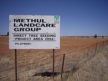
Methul is red soil wheat country in the Riverina
|
|
| Postcode(s) | 2701 |
| Elevation | 275 m (902 ft) |
| Location |
|
| LGA(s) | Coolamon Shire |
| County | Cooper |
| State electorate(s) | Cootamundra |
| Federal Division(s) | Riverina |
Methul is a small place located in the central part of the Riverina region. This area is in the south-west of New South Wales, Australia. It's known for its rich red soil, which is perfect for growing crops like wheat.
Exploring Methul's Location
Methul is situated in a rural area, meaning it's surrounded by farms and open land. It's not a big city, but a quiet locality where people live and work.
How Far is Methul?
To help you understand where Methul is, here are some distances to other places:
- It is about 14 kilometres (8.7 mi) west of a place called Rannock.
- It is also about 34 kilometres (21 mi) south of Ariah Park.
- For bigger towns, Methul is about 79 kilometres (49 mi) north-west of Wagga Wagga.
- The large city of Sydney is much further away, about 474 kilometres (295 mi) to the north-east.
Local Government and Area
Methul is part of the Coolamon Shire. A shire is like a local council area that helps manage services for the people living there. This includes things like roads and local facilities. The land around Methul, with its red soil, is very important for farming in the Riverina region.

All content from Kiddle encyclopedia articles (including the article images and facts) can be freely used under Attribution-ShareAlike license, unless stated otherwise. Cite this article:
Methul, New South Wales Facts for Kids. Kiddle Encyclopedia.

