Milecastle 17 facts for kids
Quick facts for kids Milecastle 17 |
|
|---|---|
| Northumberland, England, UK | |

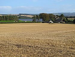
The site of Milecastle 17
|
|
|
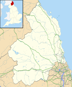
Location in Northumberland
|
|
| Coordinates | 55°00′31″N 1°54′11″W / 55.00850°N 1.90303°W |
Milecastle 17 was a small fort built by the Romans as part of Hadrian's Wall. This famous wall stretched across northern England to protect the Roman Empire. Milecastle 17 is found near the Whittle Dene reservoirs in Northumberland, England. Even today, you can see its outline on the ground.
This milecastle is special because it shows a clear change in how the wall was built nearby. This might mean different Roman army groups, called legions, worked on different parts of the wall. People have known about Milecastle 17 since at least 1732. Digs here have found many interesting things, including signs that people lived here even after the Romans left.
Contents
Building Milecastle 17
Milecastle 17 was a "short-axis" milecastle. This means it was wider from north to south than from east to west. It had special gateways called "Type I." Experts think the Legio II Augusta built these types of milecastles. This legion was based in a place called Isca Augusta (modern-day Caerleon).
The milecastle is located near Welton, Northumberland. It's about 200 meters from the Whittle Dene reservoirs. That's why it's sometimes called Welton or Whittledean Milecastle. Today, you can still see its remains as a low platform on the ground. It measures about 14.93 meters by 17.68 meters. Even though farming has made it flatter, you can still spot its shape.
A Change in the Wall
About 174 meters west of Milecastle 17, there's a big change in how Hadrian's Wall was built. This was discovered in 1931. East of this spot, the wall starts wide at the bottom and then gets narrower. West of this spot, the wall stays wide for several layers of stone before getting narrower.
Also, the western part of the wall uses smaller stones. And the small towers (turrets) near Milecastle 17 have different door styles. These differences suggest that two different Roman legions were building the wall, and this spot was their meeting point.
The Mystery of Governor Marcus
A special stone used to stand east of the milecastle. It was put there in the year 213 AD. This stone is now missing. But it was the only written record of a Roman governor named Gaius Julius Marcus. He was in charge of Roman Britain.
During that year, Marcus made many inscriptions to show his loyalty to Emperor Caracalla. Caracalla was known for being suspicious. On every other inscription, Marcus's name was erased. This might have happened because he lost the emperor's favor.
Discoveries and Digs
People have been studying Milecastle 17 for a long time. Here are some key moments:
- 1732: A person named Horseley first identified the location of the milecastle.
- 1858: Henry MacLauchlan confirmed Horseley's findings.
- 1867: Bruce also found and identified the milecastle.
- Before 1931: Early investigations showed it was a short-axis milecastle with Type I gateways. The northern wall was 3.3 meters wide and still had three layers of stone.
- 1931: More digs confirmed the milecastle's size. They found part of the northern gateway in good condition. A special part of the gate, called a pivothole liner, was found and sent to a museum.
- July 14, 1997: The milecastle was officially protected as a "Scheduled Ancient Monument." This means it's an important historical site.
- 1999: The "Milecastles Project" studied the site. They dug two trenches. One trench outside the milecastle showed signs of Roman activity, like a ditch and a pit. Inside the milecastle, they found evidence of buildings from after the Roman times, possibly an old barn.
- 1999 (later): The Centre for Archaeology also looked at the milecastle. They found that the structure was buried under a deep layer of soil. They found walls inside the milecastle that were built after the Romans left. Finds included pottery, charcoal, coal, and animal bones. They even found an unfinished ring made of jet from the 3rd century. It was likely made in Whitby.
Nearby Turrets
Every milecastle on Hadrian's Wall had two smaller watchtowers, called turrets. These turrets were placed about one-third and two-thirds of a Roman mile to the west of the milecastle. Soldiers from the milecastle would have guarded these turrets. The turrets connected to Milecastle 17 are called Turret 17A and Turret 17B.
Turret 17A (Welton East)
Turret 17A was also made a Scheduled Ancient Monument on July 14, 1997. It was dug up in 1931. Digs found a door in the southwest corner and platforms for ladders inside. A whinstone ball, possibly from a Roman weapon called a ballista, was also found. Today, you can't see any remains of this turret. It lies underneath the B3618 Military Road.
Location: 55°00′31″N 1°54′40″W / 55.008688°N 1.911003°W
Turret 17B (Horsley)
Turret 17B was protected at the same time as Turret 17A. It was found and dug up in 1931. It was similar to Turret 17A, with a door in the southwest and a ladder platform. Like 17A, it's now under the B3618 road, so there are no visible signs of it on the surface.
Location: 55°00′33″N 1°55′07″W / 55.009233°N 1.918507°W
 | Jewel Prestage |
 | Ella Baker |
 | Fannie Lou Hamer |


