Milecastle 19 facts for kids
Quick facts for kids Milecastle 19 |
|
|---|---|
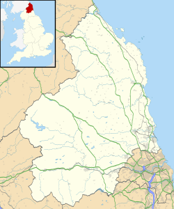
| Northumberland, England, UK | |

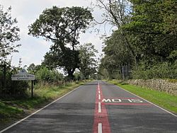
The line of Hadrian's Wall (beneath the modern road) just to the west of Milecastle 19
|
|
|
Location in Northumberland
|
|
| Coordinates | 55°00′41″N 1°56′58″W / 55.011316°N 1.949307°W |
Milecastle 19 (Matfen Piers) was a small fort built by the Romans as part of Hadrian's Wall. It's located near a small village called Matfen Piers. Today, much of this milecastle is hidden beneath the modern B6318 Military Road.
Milecastle 19 is famous because an important stone altar was found here in the 1930s. This altar has a special message carved into it. It's one of the few messages found in Roman Britain that honors a "mother goddess." The altar was set up by soldiers from the First Cohort of Varduli, who came all the way from northern Spain. Finding these soldiers here has made experts wonder about which troops guarded Hadrian's Wall.
Contents
Building Milecastle 19
Milecastle 19 was a specific type of milecastle, built longer from north to south. It had special gate designs known as "Type III gateways." Historians believe that the legio VI Victrix, a Roman army group based in York, built milecastles like this one.
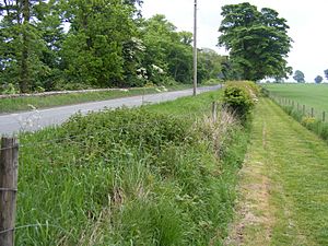
The milecastle is about 150 meters (164 yards) east of Matfen Piers. It was built on a "narrow wall" section of Hadrian's Wall. Even though part of it is under the road, you can still see a slight rise in the hedgerow. There's also a low platform in a field south of the road. The milecastle measures about 16.25 meters (17.8 yards) from east to west and 17.2 meters (18.8 yards) from north to south. It was built on a natural rock outcrop, which might have been chosen on purpose.
Discoveries and Digs
Over the years, many people have explored Milecastle 19. Here are some of the key discoveries:
- 1858 – Henry MacLauchlan first noticed the low platform of the milecastle during his survey of the wall.
- 1867 – John Collingwood Bruce also wrote about the platform in his book The Roman Wall.
- 1931–32 – Eric Birley and his team dug here. They found that the north gate was gone, but its foundations remained. A fireplace near the south gate suggested that this gate was partly blocked during Roman times. They also found a Roman altar just outside the south gate.
- 1935 – Frank G. Simpson carried out more excavations.
- 1980s – Farmers ploughing the land uncovered part of an inner building wall.
- 1997 – On July 14, Milecastle 19 was officially protected as an ancient monument.
- 1999 – English Heritage did more digging. They found that the eastern wall was made of stone and clay. The floor inside was made of sandy clay or had a cobbled area. They found some iron tools, animal bones, and a Roman coin (a Sestertius) from Emperor Hadrian's time (AD 125–138). They also found pottery, some even older than the Romans. These digs confirmed the milecastle was part of the "narrow wall" design. They also noted that farming had damaged the site.
The altar found in the 1930s was from the 2nd century AD. Birley thought there might have been a small temple or shrine nearby, or that the milecastle was later used for religious purposes.
Many altars have been found along Hadrian's Wall. But the altar at Milecastle 19 is special because of its inscription. It says: "MATRIB TEMPL CVM ARA VEX COH I VARD INSTANTE P D V VSLM". This translates to: "to the Mother Goddesses, this temple with its altarstone [was built by] a detachment of the First Cohort of Varduli, under P[ublius] D[omitius?] V[?], willingly and deservedly fulfilling their vow."
This dedication to the Matres, or "mother goddesses," is quite rare in Roman Britain. The First Cohort of Varduli soldiers are also mentioned in other places, like the Antonine Wall in Scotland. They were known to be at Corbridge around the AD 160s. This inscription has led to big discussions among experts. They wonder if Hadrian's Wall was guarded by Roman legionaries (full Roman citizens) or by non-citizen soldiers called auxilia or numeri. The altar itself is now kept at the Durham University Museum of Archaeology.
The wall at Milecastle 19 was less than 2.44 meters (8 feet) wide. There was a noticeable change in the wall's thickness just east of the milecastle. This might mean the wall was repaired later. A path used to be visible across the ditch (called a vallum) south of the milecastle. A report in the late 1990s found that Milecastle 19 was one of the few milecastles being damaged by farming.
Nearby Watchtowers
Every milecastle on Hadrian's Wall had two smaller watchtower structures, called turrets. These turrets were usually placed about one-third and two-thirds of a Roman mile to the west of the milecastle. Soldiers from the milecastle would likely have guarded them. The turrets linked to Milecastle 19 are known as Turret 19A and Turret 19B.
Turret 19A
Turret 19A (East Clarewood) is mostly hidden under the modern Military Road. However, about 5 meters (16 feet) of rough stone wall, 0.8 meters (2.6 feet) high, can still be seen in a hedge. Experts believe the door was at the western end of the turret's south wall. It seems the Romans took this turret apart, as the latest pottery found there was from 200 AD.
Eric Birley examined it in 1932. He found pottery only from the 2nd century AD. He noted that it was built similarly to other turrets, but its recess (a small alcove) was blocked up. A door frame and a hypocaust pillar (part of an ancient heating system) were found built into the wall. Irregularities in the ditch (vallum) south of Turret 19A were once visible. Turret 19A is also protected as an ancient monument.
Location on Ordnance Survey 1:25 000 map: 55°00′43″N 1°57′25″W / 55.011858°N 1.956812°W
Turret 19B
Turret 19B (West Clarewood) is also under the modern Military Road, so you can't see any remains today. It was dug up in 1932. This turret was mostly built with clay instead of mortar. Its walls were wider than usual for "narrow wall" turrets, about 2.97 meters (9.7 feet) thick. The door was at the western end of the south wall. A small, plain altar was found under a floor of flagstones.
East of the turret, gaps are again noticeable in the southern mound of the ditch (vallum). This turret is thought to have been abandoned during the 2nd century AD. Turret 19B is also protected by English Heritage, and the altar found there is protected separately.
Location on Ordnance Survey 1:25 000 map: 55°00′44″N 1°57′52″W / 55.012310°N 1.964474°W
Official Records
Here's how these Roman sites are officially recorded:
| Monument | Monument Number | English Heritage Archive Number |
| Milecastle 19 | 20455 | NZ 06 NW 4 |
| Turret 19A | 20458 | NZ 06 NW 5 |
| Turret 19B | 20461 | NZ 06 NW 6 |
| Inscribed altar associated with milecastle | 1004321 | NZ 06 NW 26 |
| Uninscribed altar found at Turret 19B | 1004325 | NZ 06 NW 27 |
 | May Edward Chinn |
 | Rebecca Cole |
 | Alexa Canady |
 | Dorothy Lavinia Brown |


