
Milecastle 33 facts for kids
Quick facts for kids Milecastle 33 |
|
|---|---|
| Northumberland, England, UK | |
_Milecastle_33_-_geograph.org.uk_-_592666.jpg)
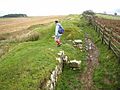
Milecastle 33 from the north
|
|

Milecastle 33
Location in Northumberland
|
|
| Coordinates | 55°01′51″N 2°15′58″W / 55.030867°N 2.266110°W |
Milecastle 33 (Shield on the Wall) was a small fort built by the Romans as part of Hadrian's Wall. This famous wall, a UNESCO World Heritage Site, stretched across northern England. Milecastles were like mini-forts placed about one Roman mile apart along the wall.
Today, you can still see the remains of Milecastle 33. Most of it looks like bumps in the ground (earthworks). Some parts, like bits of the north and south gates, are still visible above ground. The tallest part of the north wall stands about 1.2 meters (4 feet) high. You can find these remains just a few meters north of the B6318 Military Road.
Contents
Building Milecastle 33
Milecastle 33 was built in a specific way, known as a "long-axis milecastle." It had special gates called "Type II gateways." Experts believe that the legio XX Valeria Victrix, a Roman army group based in Deva Victrix (which is now Chester), built this milecastle.
The fort measured about 24 meters (78 feet) by 21 meters (68 feet). It had a large, single-piece stone at its entrance, similar to those found in other milecastles like Milecastle 13, 17, and 53.
-
Remains of the north gateway

Discovering Milecastle 33's Secrets
People have studied Milecastle 33 over the years to learn more about its history.
- 1930: A piece of decorated stone with a leaf pattern was found near the north gate.
- 1935-1936: The milecastle was dug up (excavated). This helped experts figure out its size and what was left of its structure.
- 1966: English Heritage, a group that looks after historical sites, checked the milecastle again. They confirmed what was found in the 1930s.
- 1988: English Heritage did another check as part of a big project on Hadrian's Wall. They noted that the north wall was still 1.2 meters (4 feet) high. All the earlier findings were confirmed.
Turrets Near Milecastle 33
Every milecastle on Hadrian's Wall had two smaller watchtowers, called turrets, connected to it. These turrets were placed about one-third and two-thirds of a Roman mile to the west of the milecastle. Soldiers from the milecastle would likely have guarded these turrets. The turrets linked to Milecastle 33 are called Turret 33A and Turret 33B.
_Turret_33a_-_geograph.org.uk_-_592676.jpg)
Turret 33A
Turret 33A was found in 1920. Sadly, nothing remains of it today because much of its stone was taken away over time. In 1961, an expert named Eric Birley said its location was "150 yards east of the twenty-seventh milestone at the bridge crossing the Coesike."
You can find its general location on an Ordnance Survey map here: 55°01′48″N 2°16′24″W / 55.030132°N 2.273380°W

Turret 33B (Coesike)
Turret 33B (Coesike) is about 150 meters (490 feet) west of where Hadrian's Wall and the B6318 Military Road separate. This turret has been uncovered and made stable. It stands about 1.1 meters (3.6 feet) tall.
Inside, the turret had an entrance on the east side of its south wall. There was a raised area (platform) in the southwest corner and a fireplace (hearth) in the middle. The walls were about 0.9 meters (3 feet) thick.
An important stone found here had the name of the legio VI Victrix, another Roman army group. This suggests that this legion might have built the turret originally.
Over time, the turret changed:
- The fireplace was rebuilt twice.
- The floor was raised and partly covered with flat stones.
- The stone at the door's entrance was moved.
- The turret was left empty for a while, then used again after the Romans left the Antonine Wall.
- Around the end of the 2nd century, the door was blocked up, and the turret was no longer used.
- Later, the turret was taken down to just four layers of stone, and a space in the back of the wall was filled in.
Things found at the turret show what life was like there. These include jars and cooking pots from the time of Emperor Hadrian, bones of young animals (cows, sheep, and pigs) that were eaten, and piles of ash from the fireplace dumped outside the east wall.
You can find its location on an Ordnance Survey map here: 55°01′45″N 2°16′52″W / 55.029189°N 2.281070°W
Visiting Milecastle 33
You can visit Milecastle 33, the spot where Turret 33A once stood, and Turret 33B. They are all accessible along the Hadrian's Wall Path, a walking trail that follows the ancient wall.
