
Mill River (Massachusetts–Rhode Island) facts for kids
The Mill River is a cool river that flows through two states in the U.S.: Massachusetts and Rhode Island. It's about 17.1 miles (27.5 kilometers) long, which is like running a marathon and then some!
Where the Mill River Flows
The Mill River starts its journey in a place called North Pond in Hopkinton, Massachusetts. This is near a big highway called Interstate 495. From there, it flows south into Worcester County. For a bit, it even forms the border between two towns, Upton and Milford.
The river keeps going south through other towns like Hopedale, Mendon, and Blackstone. Then, it crosses into Rhode Island. In Rhode Island, it flows through the city of Woonsocket. Finally, the Mill River joins a bigger river called the Blackstone River.
Rivers That Join the Mill River
Many smaller streams and brooks flow into the Mill River, helping it grow bigger. These smaller waterways are called tributaries. Besides many unnamed streams, some of the brooks that feed the Mill River include:
- Muddy Brook
- Round Meadow Brook
- Hop Brook
- Quick Stream
Images for kids
-
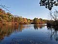
Harris Pond on Mill River in Blackstone, Massachusetts
,_October_2020.jpg)
