Missouri City, Missouri facts for kids
Quick facts for kids
Missouri City, Missouri
|
|
|---|---|

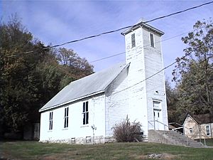
City Hall (Originally a Methodist church)
|
|

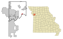
Location of Missouri City, Missouri
|
|
| Country | United States |
| State | Missouri |
| County | Clay |
| Area | |
| • Total | 1.10 sq mi (2.84 km2) |
| • Land | 1.10 sq mi (2.84 km2) |
| • Water | 0.00 sq mi (0.00 km2) |
| Elevation | 892 ft (272 m) |
| Population
(2020)
|
|
| • Total | 217 |
| • Density | 197.99/sq mi (76.41/km2) |
| Time zone | UTC-6 (Central (CST)) |
| • Summer (DST) | UTC-5 (CDT) |
| ZIP code |
64072
|
| Area code(s) | 816 |
| FIPS code | 29-48980 |
| GNIS feature ID | 2395355 |
Missouri City is a small city located in Clay County, Missouri, United States. It is part of the larger Kansas City metropolitan area. In 2020, about 217 people lived there.
Contents
History of Missouri City
Missouri City has had a few different names over the years! It was first known as Atchison. People used this name as early as 1820. Before that, French fur traders owned the land in the early 1800s.
By 1857, the name had changed to Missouri City. The town started near a place called Williams' Landing, where a ferry operated around 1834. It was also known as Richfield for a time, and then St. Bernard and New Richfield. Finally, in 1859, the areas of St. Bernard, Richfield, and Atchison officially joined together to become Missouri City.
Long ago, Missouri City was a busy place for shipping things like tobacco and hemp. However, during the American Civil War, the town faced many challenges and its businesses were almost completely destroyed. After the war, the Wabash Railroad was built through the city, which helped bring new business and growth.
The historic Missouri City Savings Bank Building and Meeting Hall is an important landmark. It was added to the National Register of Historic Places in 2010, meaning it's a special place worth preserving.
Geography of Missouri City
Missouri City covers a total area of about 1.14 square miles (2.95 square kilometers). Most of this area, about 1.01 square miles (2.62 square kilometers), is land. The rest, about 0.13 square miles (0.34 square kilometers), is water.
Population and People
Understanding the population helps us learn about the people who live in Missouri City.
Population Over Time
The number of people living in Missouri City has changed quite a bit over the years. Here's a look at the population counts from different censuses:
| Historical population | |||
|---|---|---|---|
| Census | Pop. | %± | |
| 1860 | 480 | — | |
| 1870 | 572 | 19.2% | |
| 1880 | 581 | 1.6% | |
| 1890 | 422 | −27.4% | |
| 1900 | 398 | −5.7% | |
| 1910 | 559 | 40.5% | |
| 1920 | 292 | −47.8% | |
| 1930 | 376 | 28.8% | |
| 1940 | 323 | −14.1% | |
| 1950 | 314 | −2.8% | |
| 1960 | 404 | 28.7% | |
| 1970 | 375 | −7.2% | |
| 1980 | 343 | −8.5% | |
| 1990 | 348 | 1.5% | |
| 2000 | 295 | −15.2% | |
| 2010 | 267 | −9.5% | |
| 2020 | 217 | −18.7% | |
| U.S. Decennial Census | |||
2010 Census Facts
In 2010, there were 267 people living in Missouri City. These people lived in 116 different homes, and 68 of those homes were families.
The average age of people in the city was about 46 years old. About 18% of the residents were under 18 years old. About 13% were 65 years old or older. The rest were adults between 18 and 64. Slightly more than half of the population (54.3%) was male, and 45.7% was female.
See also
 In Spanish: Missouri City (Misuri) para niños
 | Calvin Brent |
 | Walter T. Bailey |
 | Martha Cassell Thompson |
 | Alberta Jeannette Cassell |


