Mitchell, Georgia facts for kids
Quick facts for kids
Mitchell, Georgia
|
|
|---|---|

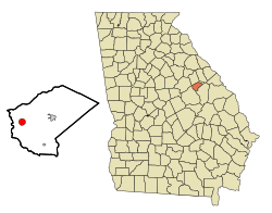
Location in Glascock County and the state of Georgia
|
|
| Country | United States |
| State | Georgia |
| County | Glascock |
| Area | |
| • Total | 1.48 sq mi (3.85 km2) |
| • Land | 1.48 sq mi (3.83 km2) |
| • Water | 0.01 sq mi (0.02 km2) |
| Elevation | 535 ft (163 m) |
| Population
(2020)
|
|
| • Total | 153 |
| • Density | 103.52/sq mi (39.96/km2) |
| Time zone | UTC-5 (Eastern (EST)) |
| • Summer (DST) | UTC-4 (EDT) |
| ZIP code |
30820
|
| Area code(s) | 706 |
| FIPS code | 13-51968 |
| GNIS feature ID | 0318336 |
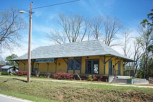
Mitchell is a small town in Glascock County, Georgia, United States. In 2020, about 153 people lived there. It is home to the Mitchell Depot Historical Museum, which used to be the town's train station.
Contents
History
Mitchell started to grow in the 1880s. This was when the railroad tracks were built to reach this area. The community was named after R. M. Mitchell. He was an important official who worked for the railroad company.
The Georgia General Assembly officially made Mitchell a town in 1896. This means it got its own local government. In 1978, a newspaper called The Los Angeles Times wrote about Mitchell. The reporter said it felt like a simpler time from long ago. People in Mitchell knew each other very well. One resident even called the town "one big security blanket." This shows how close the community was.
Geography
Mitchell is located in the western part of Glascock County. You can find it where State Routes 102 and 123 meet. State Route 102 goes east about 6 miles (10 km) to Gibson. Gibson is the main town in Glascock County. It also goes southwest about 19 miles (31 km) to Sandersville. State Route 123 goes northwest about 18 miles (29 km) to Sparta.
The United States Census Bureau says that Mitchell covers a total area of about 1.48 square miles (3.8 square kilometers). A very small part of this area, about 0.01 square miles (0.02 square kilometers), is water. The town is also located about 2 miles (3 km) east of the Ogeechee River.
People of Mitchell
| Historical population | |||
|---|---|---|---|
| Census | Pop. | %± | |
| 1900 | 246 | — | |
| 1910 | 212 | −13.8% | |
| 1920 | 257 | 21.2% | |
| 1930 | 237 | −7.8% | |
| 1940 | 228 | −3.8% | |
| 1950 | 240 | 5.3% | |
| 1960 | 184 | −23.3% | |
| 1970 | 187 | 1.6% | |
| 1980 | 214 | 14.4% | |
| 1990 | 181 | −15.4% | |
| 2000 | 173 | −4.4% | |
| 2010 | 199 | 15.0% | |
| 2020 | 153 | −23.1% | |
| U.S. Decennial Census | |||
In the year 2000, there were 173 people living in Mitchell. These people made up 72 households, and 51 of those were families. The population density was about 119 people per square mile (46 people per square kilometer). This means how many people live in a certain area. There were also 77 houses in the town.
Most of the people in Mitchell in 2000 were White (about 83.82%). The rest were African American (about 16.18%). By the year 2020, the total number of people living in Mitchell had gone down to 153.
See also
 In Spanish: Mitchell (Georgia) para niños
 | May Edward Chinn |
 | Rebecca Cole |
 | Alexa Canady |
 | Dorothy Lavinia Brown |


