Mittlerer Erzgebirgskreis Rural District facts for kids
Quick facts for kids
Mittlerer Erzgebirgskreis
|
||
|---|---|---|
|
||
 |
||
| Country | ||
| State | Saxony | |
| Capital | Marienberg | |
| Area | ||
| • Total | 595.36 km2 (229.87 sq mi) | |
| Population
(2001)
|
||
| • Total | 93,483 | |
| • Density | 157.0193/km2 (406.678/sq mi) | |
| Time zone | UTC+1 (CET) | |
| • Summer (DST) | UTC+2 (CEST) | |
| Vehicle registration | MEK | |
| Website | http://www.erzgebirge-mek.de | |
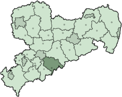
The Mittlerer Erzgebirgskreis was a special area in Germany. It was like a county or a region within the Free State of Saxony. This district doesn't exist anymore. It was officially ended in 2008.
Contents
History of the District
This district was created in 1994. It was formed by joining two older districts. These were the Marienberg district and the Zschopau district.
Geography and Nature
The Mittlerer Erzgebirgskreis was located in the Erzgebirge mountains. These mountains are also known as the Ore Mountains.
The highest point in the district was the Hirtstein. It stands tall at 891 m (2,923 ft). The lowest point was in Witzschdorf, at 305 m (1,001 ft). A large part of the district, about 40%, was covered by beautiful forests.
Understanding the Coat of Arms
Towns and Communities
Here are the main towns and smaller communities that were part of the Mittlerer Erzgebirgskreis:
| Towns | Communities (Part 1) | Communities (Part 2) |
|---|---|---|
|
|
|
 | Kyle Baker |
 | Joseph Yoakum |
 | Laura Wheeler Waring |
 | Henry Ossawa Tanner |


