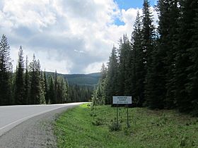
Monashee Pass facts for kids
Quick facts for kids Monashee Pass |
|
|---|---|
 |
|
| Elevation | 1,189 m (3,901 ft) |
| Traversed by | |
| Location | British Columbia, Canada |
| Range | Monashee Mountains |
The Monashee Pass is a special pathway through the Monashee Mountains in British Columbia, Canada. It is a mountain pass, which means it's a lower area between mountains. This makes it easier to travel from one side of a mountain range to the other.
The pass is about 1,189 m (3,901 ft) high. It helps connect different towns and regions in British Columbia.
Where is Monashee Pass?
Monashee Pass is located in the southern part of British Columbia. You can find it southeast of a small community called Cherryville. It is part of the Monashee Mountains. These mountains are a large range in western North America.
Why is Monashee Pass Important?
This mountain pass is very important for travel. British Columbia Highway 6 uses the Monashee Pass. This highway connects the city of Vernon to Nakusp. Nakusp is a town located on Arrow Lake.
The highway continues beyond Nakusp to other towns in the West Kootenay region. So, the pass acts like a bridge. It helps people and goods move easily across the mountains. Without it, travel would be much harder and longer.
 | William Lucy |
 | Charles Hayes |
 | Cleveland Robinson |

