Mongarlowe, New South Wales facts for kids
Quick facts for kids MongarloweNew South Wales |
|||||||||||||||
|---|---|---|---|---|---|---|---|---|---|---|---|---|---|---|---|
 |
|||||||||||||||
| Population | 117 (2016 census) | ||||||||||||||
| Postcode(s) | 2622 | ||||||||||||||
| Location | 13 km (8 mi) from Braidwood | ||||||||||||||
| LGA(s) | Queanbeyan-Palerang Regional Council | ||||||||||||||
| Region | Southern Tablelands | ||||||||||||||
| County | St Vincent | ||||||||||||||
| Parish | Budawang | ||||||||||||||
| State electorate(s) | Monaro | ||||||||||||||
| Federal Division(s) | Eden-Monaro | ||||||||||||||
|
|||||||||||||||
Mongarlowe is a small village located in the Southern Tablelands region of New South Wales, Australia. It is part of the Queanbeyan-Palerang Regional Council. In the past, this area was known by different names like Little River, Monga, and Sergeants Point. Today, the name Mongarlowe also refers to the surrounding area for things like mail delivery and population counts.
Contents
Where is Mongarlowe?
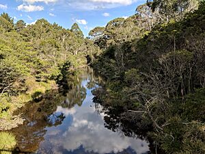
Mongarlowe is found along the Mongarlowe River, about 13 kilometers east of the town of Braidwood. According to the 2016 census, the village and its nearby areas had a population of 117 people. Some buildings from the 1800s still stand, showing that Mongarlowe was once a much bigger place. The village also has an old cemetery.
A Glimpse into Mongarlowe's Past
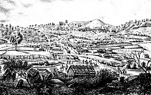
Mongarlowe was a busy mining town in the mid-1800s, especially during the New South Wales gold rush. Before 1891, it was often called Monga.
First Peoples of the Land
The land where Mongarlowe is located traditionally belongs to the Walbanga people, who are part of the Yuin nation.
After settlers arrived, Aboriginal families lost much of their land. To help them, some land was set aside as a reserve for Aboriginal people. For example, in 1879, 140 acres were reserved for an Aboriginal woman named Mary Ann Willoughby. Later, in 1885, another small reserve was created for Margaret Bryant. These reserves were later changed, and a new 50-acre reserve was set up near Currowan Creek in 1893. This reserve, called Currowan Creek Aboriginal Reserve, existed until 1956.
Many Aboriginal people living in the goldfields around Braidwood moved towards the coast in the late 1800s. This was likely to find better ways to live and get food. Mary Ann Willoughby and her children were still living near Mongarlowe in 1902.
The Gold Rush Story
People started looking for gold in the Little River (now Mongarlowe River) as early as December 1851. By March 1852, miners were already working there. The river was called "Little River" because the nearby Shoalhaven River was known as the "Big River."
By 1865, gold was being found along the river for many miles, and also in smaller valleys like Tantalean Creek. The gold was not always easy to find, so many hardworking Chinese miners came to the area. They often worked together in teams to find gold, even if the rewards were small.
Chinese miners did amazing work, like building a 16-kilometer long water channel. This channel brought water from Currawan Creek to help them wash gold from the ground in Broad Gully. You can still see many signs of their mining and sluicing work along Tantalean Creek today.
Downstream from the village, the river had created a large bend in the land, which is still called the 'Half Moon' or 'Half Moon Flat'. This area had a lot of gold that had built up over thousands of years. Another spot, 'Sydney Heads', became a mining camp. In the early 1900s, machines called dredges were used to mine gold at Half Moon.
Mongarlowe had both alluvial gold (gold found in riverbeds) and hard-rock quartz reef mines (gold found in rock veins). By 1870, miners were digging into quartz reefs. These mines were located east and northeast of the village. The Day Dawn mine was the deepest, going down 400 feet. It operated from 1884 to 1891 and again from 1900 to 1905. There was even a hard-rock mine owned by the local Chinese Nomchong family, who also ran stores in Mongarlowe and Braidwood.
A special goldfield area called 'Mongarlowe and Shoalhaven River' was officially announced on July 18, 1896.
Most major gold mining stopped after 1905. A gold dredge worked at Half Moon Flat from 1901 to 1905, then was moved to Adelong. By 1917, the future for hard-rock gold mining in Mongarlowe looked dim. However, another type of dredge worked at Half Moon off and on between 1908 and 1922. During the Great Depression, there was a small comeback in gold mining, and some activity continued until the mid-1990s.
Life in the Mining Village
The village grew up between the Mongarlowe River and Sergeants Point Creek, where it was easy to cross the river.
In its early days, the settlement had several names, including Sergeants Point and Little River. The name Mongarlowe was used from at least 1870, and the Lands Department officially called the village Mongarlowe from 1889. However, the post office and police station were called Monga. This caused confusion with another nearby place also called Monga, leading to mail going to the wrong spot. In 1891, residents asked for the postal name to be changed to Mongarlowe, and it was. From then on, Mongarlowe was the only official name for the village. The road from Braidwood to Mongarlowe is still known as Little River Road.
Mongarlowe became the main center for many smaller mining camps spread across the area. By 1870, the village had "two or three hotels, a large store, a good schoolhouse, and a police station." The wider goldfields area had ten hotels, nine stores, three mills, and in 1868, a population of 1,332 people, including 350 Chinese miners.
The village's street layout was not neatly planned but grew naturally from the original settlement.
A bridge was built across the Mongarlowe River in 1894. Before the bridge, people crossed the river using stepping stones. The old crossing point was just downstream from where the bridge was built. When the main road was changed to go over the new bridge, the town's hotel ended up with its back facing the main road!
In 1905, Mongarlowe had a police station, a hotel, three stores, a public school, a blacksmith's shop, three churches, a Chinese temple (called a 'joss house'), and private homes. Its population was about 700 Europeans and 23 Chinese people. The Chinese temple and its burial ground were on the left bank of the river, just below the old crossing. The village had a public school from 1863 to 1963.
The village's hotel, known as the 'Rising Sun Hotel', burned down in July 1907 due to arson. It was rebuilt but soon lost its license. Today, it is a private home and one of the few original public buildings left, along with the old post office and schoolhouse. Another old building, the lock-up (a small jail), was moved to the Braidwood Museum.
In January 1919, a severe bushfire hit the village. It destroyed the police station, both the Anglican and Catholic churches, several homes, a crushing battery (used for crushing ore), and the Chinese temple. This was a disaster for a village that was already getting smaller. At the time of the fire, the population was around 100 people, and by 1922, only one Chinese resident remained.
During the Great Depression, there was a small increase in population as people returned to make eucalyptus oil and search for gold again.
A new Catholic church opened in 1937 but was later taken down after being unused for some years.
Special Plants and Animals
Mongarlowe is home to some very rare plants. Three of the four known places where the critically endangered Mongarlowe Mallee (Eucalyptus recurva) grows are near the village. In 2011, there were only six of these plants left in the world!
Heritage Sites
Mongarlowe has a few places that are listed for their historical importance, including:
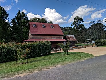
- Half Moon Road: Half Moon Farm House
 | Janet Taylor Pickett |
 | Synthia Saint James |
 | Howardena Pindell |
 | Faith Ringgold |


