
Monitor Range facts for kids

The Monitor Range is a mountain range found in the middle of southern Nevada, United States. It's a long chain of mountains that stretches from north to south.
This range is located west and northwest of the Hot Creek Range. It is also north of U.S. Route 6 in Nye County. The northern part of the range reaches into Eureka County, just south of U.S. Route 50. The town of Tonopah is about 15 miles (24 km) west of the southern end of the range. The town of Eureka is about 20 miles (32 km) east of its northern end.
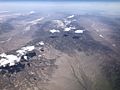
The highest point in the Monitor Range is Table Mountain. It stands tall at about 10,649 feet (3,246 meters). A special protected area called the Table Mountain Wilderness Area is located in the middle of these mountains.
Contents
Geography and Size of the Monitor Range
The Monitor Range covers a large area, about 3,046 square kilometers (1,176 square miles). This makes it a significant part of Nevada's landscape.
Valleys Around the Mountains
The mountains are surrounded by valleys. At the northern end, the Monitor Range lies between the Antelope Valley and the Monitor Valley. Further south, the mountains are found between the Toquima Range and Stone Cabin Valley.
How the Monitor Mountains Were Formed
The Monitor Range has a very straight shape. This is because it is a type of landform called a horst. Imagine a block of land that has been pushed up between two areas that have dropped down. These dropped-down areas are called grabens.
Understanding Horsts and Grabens
Think of it like this:
- A horst is a raised block of Earth's crust.
- A graben is a sunken block of Earth's crust.
This pattern of raised mountains and sunken valleys is common in south-central Nevada. It's part of a larger geological area called the basin and range topography. This means the Earth's crust in this region has been stretched and pulled apart over millions of years. This stretching causes some parts of the land to rise and others to sink.
Who Manages the Land
Different parts of the Monitor Range are managed by different groups.
- The Forest Service takes care of most of the mountains, about 83.6% of the area.
- The Bureau of Land Management (BLM) looks after about 16% of the range.
These groups work to protect the natural environment and manage how the land is used.
Plants and Trees in the Monitor Range
The Monitor Range is home to different types of plants.
- About 39.3% of the area is covered by pinon-juniper trees. These are small, hardy trees that grow well in dry climates.
- Another large part, about 24.8%, is covered by Sagebrush scrub. This means there are many low-growing shrubs, especially sagebrush.
- Montane shrub accounts for 19.9% of the plant life. These are shrubs that grow in mountainous areas.
Images for kids
-
View of the Monitor Range from above, looking north

