Mono Pass facts for kids
Quick facts for kids Mono Pass |
|
|---|---|

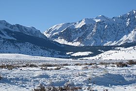
Mono Pass, winter, from the east
|
|
| Elevation | 3,230 m (10,597 ft) |
| Location | Yosemite National Park, border |
| Range | Sierra Nevada |
| Coordinates | 37°51′19.2″N 119°12′47.9″W / 37.855333°N 119.213306°W |
Mono Pass is a high mountain pass found just outside the famous Yosemite National Park. It is located near the beautiful Tuolumne Meadows area. This natural pathway cuts through the tall Sierra Nevada mountains, sitting between Mount Gibbs and Mount Lewis.
It's interesting to know that there is another pass also called Mono Pass. This second pass is less than 40 miles away in the Rock Creek/Little Lakes Valley area. Both of these Mono Passes are located within the Inyo National Forest. You can reach the Mono Pass in the Rock Creek area by using the Mosquito Flats Trailhead. The Mono Pass we are talking about here is accessed from the Mono Pass Trailhead, which is inside Yosemite National Park.
A Path Through History
Long ago, when only Native Americans lived in this region, Mono Pass was a very important place. It was part of a major trading trail. This trail went right over Mono Pass and continued through a place called Bloody Canyon. It led all the way to Mono Lake, which is just east of the Yosemite area. This route helped different groups of people trade goods and share ideas.
Finding Mono Pass
Mono Pass is technically just outside the official boundary of Yosemite National Park. However, the trail that leads to it actually starts inside the park. You can find the trailhead along the Tioga Road. It's about 1.4 miles (2.3 km) south of the park's entrance.
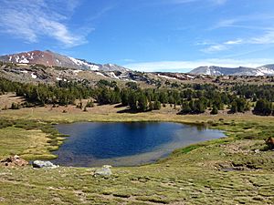
Hiking to Mono Pass is a popular activity for many visitors. The trail offers amazing views of the Sierra Nevada mountains. You can see beautiful alpine meadows and clear mountain lakes along the way. It's a great way to explore the natural beauty of this high mountain region.


