Monroe, Pennsylvania facts for kids
Quick facts for kids
Monroe, Pennsylvania
Monroeton
|
|
|---|---|
|
Borough
|
|

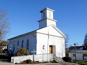
Monroeton United Methodist Church
|
|

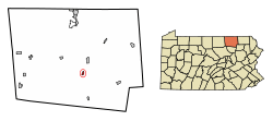
Location of Monroe in Bradford County, Pennsylvania.
|
|
| Country | United States |
| State | Pennsylvania |
| County | Bradford |
| Settled | 1828 |
| Incorporated | 1855 |
| Area | |
| • Total | 0.50 sq mi (1.29 km2) |
| • Land | 0.49 sq mi (1.28 km2) |
| • Water | 0.01 sq mi (0.02 km2) |
| Elevation | 1,047 ft (319 m) |
| Population
(2020)
|
|
| • Total | 478 |
| • Density | 967.61/sq mi (373.80/km2) |
| Time zone | UTC-5 (Eastern (EST)) |
| • Summer (DST) | UTC-4 (EDT) |
| ZIP Code |
18832
|
| Area code(s) | 570 |
| FIPS code | 42-50432 |
Monroe is a small town in Bradford County, Pennsylvania, United States. It is also often called Monroeton. This area is part of Northeastern Pennsylvania. In 2020, about 482 people lived here.
Contents
Exploring Monroe's Location and Landscape
Monroe, or Monroeton, is found in the southern part of Bradford County. It sits in a valley near Towanda Creek. This creek eventually flows into the Susquehanna River. The town is surrounded by Monroe Township. However, the borough of Monroe is a separate area. In 1940, people described Monroeton as a "Y-shaped farming village." It had many small houses covered in vines.
How to Get Around Monroe
U.S. Route 220 goes right through the town. If you head north on this road, you'll reach Towanda in about 4 miles (6 km). Towanda is the county seat, which means it's where the main government offices for the county are. Going south on Route 220, you'll find New Albany about 9 miles (14 km) away. Another road, Pennsylvania Route 414, leads west from Monroeton to Canton, which is about 21 miles (34 km) away.
Monroe's Size and Water Areas
According to the U.S. Census Bureau, Monroe covers a total area of about 0.50 square miles (1.3 square kilometers). Most of this area is land. Only a tiny part, about 0.01 square miles (0.02 square kilometers), is water.
Monroe or Monroeton?
Even though the official name of the town is "Monroe," most people who live there call it "Monroeton." The local post office is named "Monroeton, PA 18832." Also, the road signs at the edge of town say "Monroeton."
Monroe's Population Over Time
| Historical population | |||
|---|---|---|---|
| Census | Pop. | %± | |
| 1860 | 244 | — | |
| 1870 | 293 | 20.1% | |
| 1880 | 383 | 30.7% | |
| 1890 | 496 | 29.5% | |
| 1900 | 385 | −22.4% | |
| 1910 | 403 | 4.7% | |
| 1920 | 405 | 0.5% | |
| 1930 | 414 | 2.2% | |
| 1940 | 428 | 3.4% | |
| 1950 | 466 | 8.9% | |
| 1960 | 502 | 7.7% | |
| 1970 | 627 | 24.9% | |
| 1980 | 627 | 0.0% | |
| 1990 | 540 | −13.9% | |
| 2000 | 514 | −4.8% | |
| 2010 | 554 | 7.8% | |
| 2020 | 482 | −13.0% | |
| 2021 (est.) | 487 | −12.1% | |
| Sources: | |||
The population of Monroe has changed over the years. In 1860, there were 244 people living there. The population grew steadily for many years, reaching its highest point in 1970 and 1980 with 627 residents. Since then, the number of people living in Monroe has decreased a bit. In 2020, the population was 482.
Who Lives in Monroe?
In 2000, there were 514 people living in Monroe. Most residents were White. About 33.8% of the homes had children under 18. Many families were married couples living together. The average age of people in Monroe was 40 years old.
See also
 In Spanish: Monroe (Pensilvania) para niños
 | Sharif Bey |
 | Hale Woodruff |
 | Richmond Barthé |
 | Purvis Young |


