Monségur, Gironde facts for kids
Quick facts for kids
Monségur
|
||
|---|---|---|

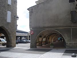
Arcades and hall
|
||
|
||
| Country | France | |
| Region | Nouvelle-Aquitaine | |
| Department | Gironde | |
| Arrondissement | Langon | |
| Canton | Le Réolais et Les Bastides | |
| Intercommunality | Monségurais | |
| Area
1
|
9.91 km2 (3.83 sq mi) | |
| Population
(Jan. 2019)
|
1,604 | |
| • Density | 161.86/km2 (419.2/sq mi) | |
| Time zone | UTC+01:00 (CET) | |
| • Summer (DST) | UTC+02:00 (CEST) | |
| INSEE/Postal code |
33289 /33580
|
|
| Elevation | 17–111 m (56–364 ft) | |
| 1 French Land Register data, which excludes lakes, ponds, glaciers > 1 km2 (0.386 sq mi or 247 acres) and river estuaries. | ||
Monségur is a small town, also known as a commune, located in the southwest of France. It is part of the Gironde department within the Aquitaine region.
About Monségur
Monségur is a charming French commune. It is known for its traditional arcades and a central hall, as shown in the picture. These features often point to a rich history, as many towns in this area were built centuries ago.
Location and Geography
Monségur is situated in a beautiful part of France. Its lowest point is 17 meters (about 56 feet) above sea level, and its highest point reaches 111 meters (about 364 feet). The commune covers an area of 9.91 square kilometers (about 3.83 square miles).
Population
As of January 2019, about 1,604 people lived in Monségur. This number is counted by the National Institute of Statistics and Economic Studies in France.
Local Government
Like all communes in France, Monségur has a mayor who leads the local government. The mayor helps manage the town's services and represents its people. From 2008 to 2014, Jean-Louis Favereau served as the mayor of Monségur.
See also
 In Spanish: Monségur (Gironda) para niños
 | Calvin Brent |
 | Walter T. Bailey |
 | Martha Cassell Thompson |
 | Alberta Jeannette Cassell |


