Montane racket-tail facts for kids
Quick facts for kids Montane racket-tail |
|
|---|---|
 |
|
| Conservation status | |
| Scientific classification |
|
| Kingdom: | Animalia |
| Phylum: | Chordata |
| Class: | Aves |
| Order: | Psittaciformes |
| Family: | Psittaculidae |
| Genus: | Prioniturus |
| Species: |
P. montanus
|
| Binomial name | |
| Prioniturus montanus Ogilvie-Grant, 1895
|
|
| Script error: The function "autoWithCaption" does not exist. | |
Script error: No such module "Check for conflicting parameters".
The montane racket-tail (Prioniturus montanus), also called the Luzon racket-tail, is a cool type of parrot that lives in the mountains of the Philippines. It's known for its unique tail feathers that look like little rackets! This bird is special because it's only found in the northern parts of Luzon, one of the biggest islands in the Philippines. Sadly, it's facing some challenges, like losing its home in the forests and sometimes being caught to be sold as a pet.
Contents
Discover the Montane Racket-tail
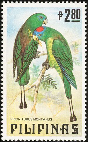
The montane racket-tail is a medium-sized parrot. It lives in the mountain forests of Luzon. Its most unique feature is its tail. The two middle tail feathers have long shafts. These shafts end in a shape that looks like a small racket.
This parrot is mostly green. Its back is a darker green, and its belly is a lighter green.
Spotting the Differences
Male and female montane racket-tails look a bit different. This is called sexual dimorphism.
- Males have a blue face and a bright red spot on their head.
- Females have a green head. They might have a very light blue hint on their head.
There's another parrot, the Green racket-tail, that looks similar. However, the Luzon racket-tail usually lives in higher mountain areas. It also has a darker green back.
What Does It Eat?
The montane racket-tail enjoys a diet of different plant foods. It likes to eat berries, seeds, and nuts found in its forest home.
Life Cycle and Reproduction
Montane racket-tails usually breed between August and September. Like other racket-tail parrots, they are cavity nesters. This means they make their nests inside holes in trees.
Where It Lives and How We Can Help
This parrot lives in tropical moist mountain forests. You can find it at elevations from about 700 to 2,900 meters (about 2,300 to 9,500 feet) above sea level. Sometimes, it even visits areas where people grow crops.
Its Conservation Status
The International Union for Conservation of Nature (IUCN) has listed the montane racket-tail as "near threatened". This means it could become endangered in the future if we don't protect it. Scientists estimate there are about 1,500 to 7,000 adult birds left.
One big problem for these parrots is losing their forest homes. However, this is not as big a problem for them as it is for parrots living in lower areas. For example, the Green racket-tail, which lives in lowlands, is much more threatened. It is listed as endangered. Many of its local groups have disappeared.
Another concern is that many parrots in this region are caught and sold as pets. We don't know exactly how much this affects the montane racket-tail.
How to Protect This Parrot
Experts suggest several ways to help the montane racket-tail:
- Gather Information: We need to learn more about how being caught and sold affects these birds.
- Count Them: More surveys are needed to get a better idea of how many birds are truly out there.
- Track Forest Loss: We should use satellite images to see how fast their forest homes are disappearing.
- Protect Homes: It's important to protect the key forest areas where these parrots live.
 | Sharif Bey |
 | Hale Woodruff |
 | Richmond Barthé |
 | Purvis Young |


