Montavilla, Portland, Oregon facts for kids
Quick facts for kids
Montavilla
|
|
|---|---|
|
Neighborhood
|
|
| Country | United States |
| State | Oregon |
| City | Portland |
| Area | |
| • Total | 2.18 sq mi (5.64 km2) |
| Population
(2010)
|
|
| • Total | 16,287 |
| • Density | 7,479/sq mi (2,887.8/km2) |
| Housing | |
| • No. of households | 6,579 |
| • Occupancy rate | 95% occupied |
| • Owner-occupied | 3,817 households (58%) |
| • Renting | 2,762 households (42%) |
| • Avg. household size | 2.48 persons |
Montavilla is a neighborhood in Portland, Oregon, United States. It is located in both the Northeast and Southeast parts of the city. The name "Montavilla" is a shorter way of saying "Mt. Tabor Village." This area is found east of Mount Tabor and west of Interstate 205. It stretches from the Banfield Freeway to SE Division Street. Montavilla shares borders with several other neighborhoods. These include North Tabor, Mount Tabor, South Tabor, Madison South, Hazelwood, and Powellhurst-Gilbert.
History of Montavilla
The Montavilla neighborhood has a cool history. In the 1890s, it was known as Mount Tabor Village. It was a popular stop for people traveling between Hood River and Portland.
How Montavilla Got Its Name
The name "Montavilla" came from the streetcar signs. When streetcars started serving the area in 1892, they needed shorter names. First, they used "Mt. Ta. Villa," then later "Monta.Villa." People living there liked the shorter name "Montavilla," and it stuck! Streetcar service in Montavilla stopped in 1948.
Old Road Markers
You can still find a stone marker on SE Stark Street at 78th Avenue. This marker, called the P5 marker, is from an old road built around 1854. This road, called Base Line Road, went from the Sandy River to the Willamette River. The marker shows that it's five miles to the downtown courthouse. It's one of the markers that helps show the Willamette baseline.
Neighborhood Development
In the early to mid-1950s, a new housing area called the Asbahr Addition was built. It was located between SE 89th and SE 92nd Avenues. Most of the houses built there were ranch-style homes. A building called Chinese Village was a well-known spot in the neighborhood for a long time. It was taken down in July 2018. The Monastery of the Precious Blood, built in 1923, is a historic building. It is listed on the National Register of Historic Places and is located on 76th Avenue.
Housing Planning in Montavilla's Past
In the past, some housing practices made it harder for certain groups of people to live in Montavilla. A map from 1934, which used a practice called redlining, marked areas in Montavilla as "Definitely Declining." This meant that banks and others were less likely to invest there. The map also mentioned that some groups of people were seen as a "threat" to the area.
Later, in 1947, some housing developments had unfair rules called racist covenants. For example, the Park Terrace Homes development had a rule that said, "No race or nationality other than those of the Caucasian or White race shall occupy any dwelling." This meant that only white people could live there, except for domestic helpers. These rules were unfair and made it difficult for many people to find homes in certain areas.
Montavilla Community Life
Montavilla has a strong community spirit. The Montavilla Food Co-op started in 2010. It is working to open a community-owned grocery store in the neighborhood. Pollinator Parkways is another group that helps the environment. They turn grassy areas next to streets into homes for wildlife.
The Montavilla East Tabor Business Association puts on the Montavilla Street Fair every summer. Thousands of people come to enjoy this event on SE Stark Street. The Montavilla Emergency Warming Shelter and Rahab's Sisters help people in need. They both operate from St. Peter and Paul Church. The Montavilla Farmers Market is held on Sundays at 77th and Stark. The southern part of the neighborhood is also home to the Jade District, which is a lively business and cultural area.
Parks in Montavilla
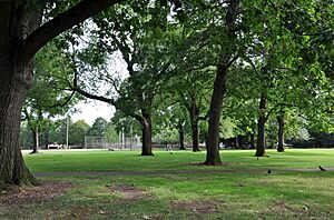
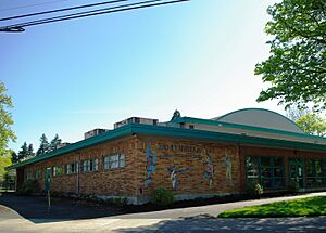
Montavilla is home to several parks where you can play and relax. Montavilla Park is a large park, about 9.46 acres, that opened in 1921. It has a futsal field, which is like a small soccer field, sponsored by the Portland Timbers. Montavilla also has Berrydale Park, Harrison Park, and the Montavilla Community Center. Vestal Community Garden is a place where people can grow plants.
In case of a big earthquake, Montavilla Park is an important spot. It will serve as a Basic Earthquake Emergency Communication Nodes Site. This means it's one of the city's official places to get help if phones are not working. You can also report serious damage or injuries there. Montavilla Park is located where Glisan Street and 82nd Avenue meet.
Schools in Montavilla
Montavilla has schools for different age groups. Vestal K-5 is an elementary school focused on social justice. It's near the center of the neighborhood, west of 82nd Avenue. Clark Elementary K-5 school is west of 92nd Avenue. Harrison Park Middle 6-8 is a middle school near the southern end of the neighborhood. It is located on SE 87th Avenue in the Jade District.
The neighborhood also has places for higher education. Multnomah University is a Christian university north of Glisan Street. Portland Community College Southeast campus is at the southwest edge of the neighborhood. It is located at 82nd Avenue and Division Street.
Stark Street: A Neighborhood Hub
SE Stark Street, between 75th and 82nd Avenues, is a busy center for the neighborhood. It has many shops and services for people who live there and visitors. It's a great place to meet friends, do errands, look at shop windows, and eat at local restaurants. The Academy Theater, built in 1948 and fixed up in 2006, is a key spot in this area.
Glisan Street: More to Explore
Glisan Street is mainly for cars, but the area west of 82nd Avenue has many small businesses. You can find different places to eat, as well as medical offices, gift shops, salons, and auto repair shops. There are also religious buildings along this street.
Getting Around Montavilla
Montavilla is easy to get to because of its main roads. Division Street, I-84, and I-205 are big roads that connect the neighborhood to downtown and other areas. Inside Montavilla, Glisan, Burnside, and Stark Streets run east-west. 82nd Avenue runs north-south. All these are important streets with TriMet bus lines.
The Max light rail train has one stop in Montavilla, at 82nd Avenue. Another stop is at the Gateway/Northeast 99th Avenue Transit Center, just outside the neighborhood. The neighborhood will also get a new bike path called the Seventies Neighborhood Greenway. This will make it easier and safer for people to bike and walk north-south near NE 82nd Avenue. Other greenways for bikes and walkers are already on 86th Avenue and Mill Street.
82nd Avenue: A Key Road
82nd Avenue is a major road that goes through the middle of Montavilla. It's a very busy street with many businesses. It is surrounded by neighborhoods with mostly single-family homes. Because 82nd Avenue runs through the neighborhood, people often need to cross this five-lane road to get to school, work, or for fun.
Some intersections on 82nd Avenue, like at Glisan Street, have had many accidents. The City of Portland has even said the intersection of 82nd and Glisan is one of the most challenging for people walking. The intersections with SE Division and E Burnside also have more accidents. To make 82nd Avenue better and safer, a group called the 82nd Avenue Improvement Coalition was formed. One of their main goals was to have the City of Portland take over control of 82nd Avenue from the state. In the spring of 2022, the Portland City Council agreed to this plan. This change should help bring improvements to the road.
 | Delilah Pierce |
 | Gordon Parks |
 | Augusta Savage |
 | Charles Ethan Porter |


