Willamette Stone facts for kids
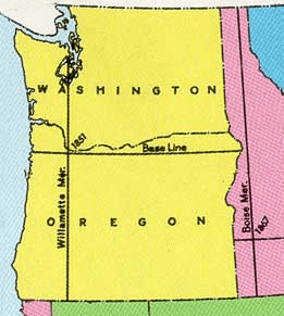
The Willamette Stone is a special stone marker in the hills west of Portland, Oregon. It marks the exact spot where two important imaginary lines cross: the Willamette Meridian (a north-south line) and the Willamette Baseline (an east-west line). Think of it like the center point of a giant map grid.
This stone replaced an older wooden stake that was placed in 1851. That first marker, and later the stone, helped create a system for measuring all the land in Oregon and Washington. This system was very important, especially after a law in 1850 called the Donation Land Claim Act. This law allowed people to claim land in the Oregon Territory. The Willamette Stone helped make sure everyone knew exactly where their land was.
Contents
History of the Willamette Stone
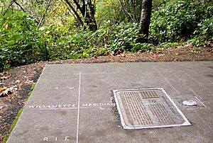
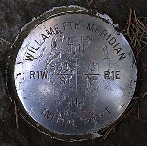
Today, the original stone is gone. Instead, you'll find a shiny stainless steel marker at the Willamette Stone State Heritage Site. This site is an Oregon state park located about four miles (6.4 km) west of downtown Portland. It's a cool spot to visit, with views of the Tualatin Valley and the Willamette River.
Why the Stone is Important
The grid system started by the Willamette Stone helped measure land across the whole Oregon Territory. It was part of a bigger system called the Public Land Survey System. The very first marker, a red cedar stake, was put in place on June 4, 1851. This was done by John B. Preston, who was the first Surveyor General for the Oregon Territory. President Millard Fillmore chose Preston to set up this land-measuring system.
Surveyors used special tools called solar compasses to draw these lines. They made sure the main east-west line (the baseline) didn't cross the Columbia River. They also made sure the main north-south line (the meridian) was west of Vancouver Lake. This careful planning helped create the first "townships" and "ranges" (parts of the land grid) that spread out from the marker.
Changes to the Marker
The original wooden stake was replaced by a stone marker on July 25, 1885. This stone had "BASE" and "LINE" carved on two sides, and "WILL." and "MER." on the other two.
Sadly, the stone was damaged in the 1980s. So, the government replaced it with the marker you see today. There's also a bronze plaque that explains its importance: "Beginning here, the Willamette meridian was established running north to Puget Sound and south to the California border, and the baseline was established running east to the Idaho border and west to the Pacific Ocean." This shows how far the lines from this small stone reach!
Streets That Follow the Lines
You can often find streets that follow or run next to the Willamette Meridian and Baseline. Sometimes, these streets are even named to show their connection to these important survey lines.
North-South Streets and the Meridian
Some streets are named "Meridian Road" because they follow the Willamette Meridian. You can find these in places like Clackamas County, Marion County, Linn County, and Jackson County in Oregon. In Washington, there are Meridian Roads in Thurston County, Washington and Kitsap County, Washington.
Other streets also follow the meridian, even if they aren't named after it. For example, parts of SW 65th Avenue in Multnomah County and a small section of Interstate 5 run along the meridian.
East-West Streets and the Baseline
Many "Baseline Road" streets in Oregon follow or start at the Willamette Baseline. You can see these in Tillamook, Washington, Hood River, Gilliam, and Morrow counties.
Also, Stark Street in east Portland and Washington County follows the Willamette Baseline.
 | Emma Amos |
 | Edward Mitchell Bannister |
 | Larry D. Alexander |
 | Ernie Barnes |


