Montpelier Historic District (Vermont) facts for kids
|
Montpelier Historic District
|
|

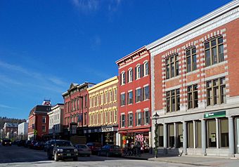
State Street view
|
|
| Location | U.S. 2 and VT 12, Montpelier, Vermont |
|---|---|
| Area | 237 acres (96 ha) (original size) 7.5 acres (3.0 ha) (size of 1989 increase) |
| Built | 1805 |
| Architectural style | Mixed (more Than 2 Styles From Different Periods), Federal |
| NRHP reference No. | 78000246 (original) 89000248 (increase 1) 100002105 (increase 2) |
Quick facts for kids Significant dates |
|
| Added to NRHP | November 3, 1978 |
| Boundary increases | April 17, 1989 February 20, 2018 |
The Montpelier Historic District is a special area in Montpelier, Vermont, which is the capital city of Vermont. This district includes many old and important buildings, like the main government offices and busy shops. It's located where the Winooski River meets its North Branch.
Montpelier became the state capital in 1805. This helped the city grow a lot! The buildings in the district show off different styles from the 1800s. Besides the Vermont State House (where laws are made), you can find The Pavilion and the main shopping area here. This historic district was first recognized in 1978 and has been made larger twice since then.
Contents
How Montpelier Grew Over Time
Montpelier was started in 1781. It was a quiet farming town until 1805, when it was chosen to be the state capital. This happened because it was easy to reach by roads and rivers, and it was in the middle of Vermont. Becoming the capital made the town grow very quickly!
Early Development and Important Streets
After 1805, a street called State Street became very important. It connected the state government buildings to the town center. In 1811, Montpelier also became the main town for what is now Washington County. This meant even more growth and activity.
Industry and the Railroad's Impact
The town's industries, like mills, got a big boost when the railroad arrived in 1849. This made it easier to bring goods in and out. After the American Civil War, Montpelier's economy really took off! It officially became a city in 1895.
Changes in the 20th Century
Growth started to slow down after World War I. More people began using cars and moving to areas outside the city center. This changed how towns developed across the country.
What Makes the Historic District Special?
The Montpelier Historic District is shaped by two important rivers: the North Branch and the Winooski River. The main part of the city, with its shops and businesses, is mostly northeast of where these two rivers meet.
Streets and Buildings
Major roads follow these rivers. State Street goes west towards the state capitol building. Barre Street and Berlin Street go east. Main Street runs north and south, then turns east where it meets Elm Street. The hills around Montpelier make the streets curve and turn. Many of the brick buildings you see in the main business area were built after two big fires in 1875.
 | William M. Jackson |
 | Juan E. Gilbert |
 | Neil deGrasse Tyson |


