Montreal River (Algoma–Sudbury, Ontario) facts for kids
Quick facts for kids Montreal River |
|
|---|---|

Mouth of the Montreal River at Lake Superior
|
|
|
Location of the mouth of the Montreal River in Ontario
|
|
| Country | Canada |
| Province | Ontario |
| Districts |
|
| Physical characteristics | |
| Main source | Montreal Lake Island Lake, Sudbury District 447 m (1,467 ft) 47°42′24″N 83°33′50″W / 47.70667°N 83.56389°W |
| River mouth | Montreal River Harbour, Algoma District 180 m (590 ft) 47°14′20″N 84°38′45″W / 47.23889°N 84.64583°W |
| Length | 130 km (81 mi) |
The Montreal River is a river located in Ontario, Canada. It flows through the Algoma and Sudbury areas. This river is an important branch, also called a tributary, that flows into the huge Lake Superior.
Contents
Exploring the Montreal River's Path
The Montreal River starts its journey at Montreal Lake. This lake is found near a small place called Island Lake in the northwest part of Sudbury District.
How the River Flows
From Montreal Lake, the river travels southwest. It then enters the Algoma District. Along its path, it forms a large lake-like area called a forebay, which is about 40 kilometers (25 miles) long. This forebay is located just above Montreal Falls.
The river then reaches the area of Montreal Falls itself. Here, you can find a small settlement and a railway station that belongs to the Algoma Central Railway. After this, the river turns west. It flows under Ontario Highway 17 just before it reaches its final destination. The Montreal River empties into Lake Superior at a community known as Montreal River Harbour.
Power from the River: Hydroelectricity
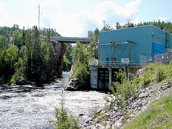
The Montreal River is used to create electricity! There are four special power plants along the river. These plants use the force of the flowing water to make hydroelectric power.
Who Operates the Power Plants?
All four of these power plants are owned and run by a company called Brookfield Renewable Power. They help provide clean energy to the area.
Major Power Stations on the River
The power stations are listed here starting from the one furthest upstream (closer to the river's source) and moving downstream:
- MacKay Generating Station: This plant is located at Montreal Falls. It is the largest, producing 62 megawatts (MW) of power. It uses a drop in water level of about 75.3 meters (247 feet).
- Gartshore Generating Station: This station produces 23 MW of power. It uses a water drop of about 35 meters (115 feet).
- Hogg Generating Station: This plant generates 17.4 MW of power. It uses a water drop of about 24 meters (79 feet).
- Andrews Generating Station: This is the furthest downstream, located next to Highway 17. It produces 57.78 MW of power. It uses a water drop of about 57.78 meters (190 feet).
Smaller Rivers and Creeks Joining the Montreal River
Many smaller rivers and creeks flow into the Montreal River, adding to its water. These are called tributaries. They join the main river from either the left or the right side as you look downstream.
Tributaries Joining from the Right
- Little Agawa River
- Sonny Creek
- Jeff Creek
- Rabbit Creek
- Indian River
- Convey Creek
- Tikamaganda River
- Harvie Creek
- Seahorse Creek
- Nawahe Creek
Tributaries Joining from the Left
- Cow River
- Keelow Creek
- Challener River
- Tempest Creek
- Puswana Creek
- Ebach Creek
- Sample Creek
- Pemache River
 | Georgia Louise Harris Brown |
 | Julian Abele |
 | Norma Merrick Sklarek |
 | William Sidney Pittman |


