Mooney Mooney Creek, New South Wales facts for kids
Quick facts for kids Mooney Mooney CreekCentral Coast, New South Wales |
|||||||||||||||
|---|---|---|---|---|---|---|---|---|---|---|---|---|---|---|---|

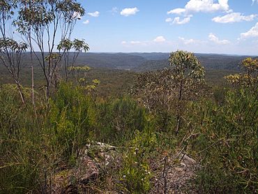
Mooney Mooney Creek from Scopas Peak, Central Coast
|
|||||||||||||||
| Postcode(s) | 2250 | ||||||||||||||
| Elevation | 152 m (499 ft) | ||||||||||||||
| Location | |||||||||||||||
| LGA(s) | Central Coast Council | ||||||||||||||
| Parish | Cowan | ||||||||||||||
| State electorate(s) | Gosford | ||||||||||||||
| Federal Division(s) | Robertson | ||||||||||||||
|
|||||||||||||||
Mooney Mooney Creek is a small area, or suburb, located on the Central Coast of New South Wales, Australia. It's about 60 kilometers (37 miles) north of Sydney. This place gets its name from the river that flows through it.
It's part of the Central Coast Council, which is like the local government that helps manage the area.
Exploring Mooney Mooney Creek
Mooney Mooney Creek is a unique place because most of its land is part of a huge natural area. This area is called the Brisbane Water National Park. Imagine a suburb that's almost entirely a national park!
Nature's Playground: Brisbane Water National Park
Being part of the Brisbane Water National Park means Mooney Mooney Creek is home to lots of amazing plants and animals. It's a great spot for nature lovers. You can find beautiful bushland, waterways, and maybe even some native wildlife.
Getting Around
Even though it's mostly a national park, important roads pass through Mooney Mooney Creek. The Pacific Motorway and the Pacific Highway both go through the western and northern parts of the suburb. These roads help people travel between Sydney and Newcastle.
 | Claudette Colvin |
 | Myrlie Evers-Williams |
 | Alberta Odell Jones |

