Moorhead, Mississippi facts for kids
Quick facts for kids
Moorhead, Mississippi
|
|||
|---|---|---|---|

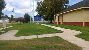
Entrance sign
|
|||
|
|||

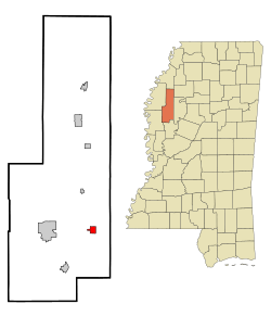
Location of Moorhead, Mississippi
|
|||
| Country | United States | ||
| State | Mississippi | ||
| County | Sunflower | ||
| Area | |||
| • Total | 1.29 sq mi (3.35 km2) | ||
| • Land | 1.29 sq mi (3.35 km2) | ||
| • Water | 0.00 sq mi (0.00 km2) | ||
| Elevation | 115 ft (35 m) | ||
| Population
(2020)
|
|||
| • Total | 1,937 | ||
| • Density | 1,495.75/sq mi (577.39/km2) | ||
| Time zone | UTC-6 (Central (CST)) | ||
| • Summer (DST) | UTC-5 (CDT) | ||
| ZIP code |
38761
|
||
| Area code(s) | 662 | ||
| FIPS code | 28-48760 | ||
| GNIS feature ID | 2404297 | ||
Moorhead is a city located in Sunflower County, Mississippi, in the United States. It's a smaller city with a population of about 1,937 people, according to the 2020 census. Moorhead is known for its important role in the history of blues music.
Contents
Geography and Location
Moorhead covers a total area of about 1.3 square miles (3.35 square kilometers). Almost all of this area is land.
The city is situated along U.S. Route 82. This highway runs east of Indianola. Moorhead is also where U.S. Route 82 meets Mississippi Highway 3.
Railroad Crossroads
Moorhead is famous for being the meeting point of two important railroads. These were the Southern and the Yazoo Delta Railroad. This special spot is known as the "crossroads." It's a legendary place in blues music history.
Moorhead's Climate
Moorhead has a humid subtropical climate. This means it has hot, humid summers and mild winters. The city gets a good amount of rain throughout the year.
| Climate data for Moorhead, Mississippi (1991–2020 normals, extremes 1913–2019) | |||||||||||||
|---|---|---|---|---|---|---|---|---|---|---|---|---|---|
| Month | Jan | Feb | Mar | Apr | May | Jun | Jul | Aug | Sep | Oct | Nov | Dec | Year |
| Record high °F (°C) | 83 (28) |
89 (32) |
90 (32) |
94 (34) |
101 (38) |
109 (43) |
110 (43) |
108 (42) |
108 (42) |
99 (37) |
88 (31) |
85 (29) |
110 (43) |
| Mean daily maximum °F (°C) | 52.2 (11.2) |
56.6 (13.7) |
65.2 (18.4) |
73.7 (23.2) |
81.7 (27.6) |
87.9 (31.1) |
90.6 (32.6) |
91.3 (32.9) |
87.2 (30.7) |
76.9 (24.9) |
64.1 (17.8) |
55.1 (12.8) |
73.5 (23.1) |
| Daily mean °F (°C) | 43.7 (6.5) |
47.6 (8.7) |
55.7 (13.2) |
64.2 (17.9) |
72.7 (22.6) |
79.3 (26.3) |
82.0 (27.8) |
82.0 (27.8) |
76.8 (24.9) |
66.1 (18.9) |
54.1 (12.3) |
46.6 (8.1) |
64.2 (17.9) |
| Mean daily minimum °F (°C) | 35.1 (1.7) |
38.7 (3.7) |
46.2 (7.9) |
54.7 (12.6) |
63.7 (17.6) |
70.8 (21.6) |
73.4 (23.0) |
72.6 (22.6) |
66.3 (19.1) |
55.4 (13.0) |
44.1 (6.7) |
38.1 (3.4) |
54.9 (12.7) |
| Record low °F (°C) | −7 (−22) |
−10 (−23) |
14 (−10) |
28 (−2) |
38 (3) |
42 (6) |
51 (11) |
51 (11) |
35 (2) |
24 (−4) |
14 (−10) |
0 (−18) |
−10 (−23) |
| Average precipitation inches (mm) | 5.11 (130) |
5.39 (137) |
5.48 (139) |
6.17 (157) |
4.65 (118) |
3.89 (99) |
4.24 (108) |
3.06 (78) |
3.53 (90) |
3.89 (99) |
4.68 (119) |
5.67 (144) |
55.76 (1,418) |
| Average snowfall inches (cm) | 0.4 (1.0) |
0.1 (0.25) |
0.0 (0.0) |
0.0 (0.0) |
0.0 (0.0) |
0.0 (0.0) |
0.0 (0.0) |
0.0 (0.0) |
0.0 (0.0) |
0.0 (0.0) |
0.0 (0.0) |
0.0 (0.0) |
0.5 (1.25) |
| Average precipitation days (≥ 0.01 in) | 10.4 | 10.0 | 11.0 | 9.5 | 9.2 | 8.7 | 9.4 | 7.9 | 6.3 | 7.1 | 9.3 | 11.5 | 110.3 |
| Average snowy days (≥ 0.1 in) | 0.2 | 0.1 | 0.0 | 0.0 | 0.0 | 0.0 | 0.0 | 0.0 | 0.0 | 0.0 | 0.0 | 0.0 | 0.3 |
| Source: NOAA | |||||||||||||
Population and Demographics
Moorhead's population has changed over the years. In 2010, about 2,405 people lived there. By 2020, the population was 1,937.
| Historical population | |||
|---|---|---|---|
| Census | Pop. | %± | |
| 1900 | 437 | — | |
| 1910 | 506 | 15.8% | |
| 1920 | 1,600 | 216.2% | |
| 1930 | 1,553 | −2.9% | |
| 1940 | 1,504 | −3.2% | |
| 1950 | 1,749 | 16.3% | |
| 1960 | 1,754 | 0.3% | |
| 1970 | 2,284 | 30.2% | |
| 1980 | 2,358 | 3.2% | |
| 1990 | 2,417 | 2.5% | |
| 2000 | 2,573 | 6.5% | |
| 2010 | 2,405 | −6.5% | |
| 2020 | 1,937 | −19.5% | |
| U.S. Decennial Census | |||
Population Makeup in 2020
In 2020, Moorhead had 1,937 residents. There were 522 households and 313 families living in the city.
The community is made up of people from different backgrounds.
| Race | Num. | Perc. |
|---|---|---|
| White | 426 | 21.99% |
| Black or African American | 1,443 | 74.5% |
| Asian | 4 | 0.21% |
| Other/Mixed | 19 | 0.98% |
| Hispanic or Latino | 45 | 2.32% |
Population Makeup in 2010
In 2010, the city's population was 2,405 people. Most residents, about 82.2%, were Black. About 16.3% were White. A small number of residents were Native American, Asian, or from two or more races. About 0.7% of the population was Hispanic or Latino.
Arts and Culture

Moorhead holds a special place in the history of blues music. A historic marker in the city shows where two famous railroads once crossed. These were the Southern Railroad and the Yazoo Delta Railroad. The Yazoo Delta Railroad was also known as the "Yellow Dog."
The Southern Railroad ran from east to west. It later became the Columbus and Greenville Railway. The "Yellow Dog" ran north to south. It later became the Yazoo and Mississippi Valley Railroad. Even though the north-south line is no longer used in Moorhead, the spot where the two lines crossed is still preserved as a historic site.
The Birth of the Blues
This railroad crossing is very important to blues music. It's believed that W. C. Handy, a famous musician, was inspired here. He heard an old man singing about "where the Southern cross the Yellow Dog." This sound deeply moved Handy and helped start what we now know as the "blues."
Education in Moorhead
The schools in Moorhead are part of the Sunflower County Consolidated School District. This district helps manage education for the city's young people.
Local Schools
- Moorhead Central School: This school serves students from kindergarten through 8th grade. It used to be called Moorhead Middle School.
- James C. Rosser Early Learning Center: This center helps younger students. It was formerly known as James Rosser Elementary School.
Older students from Moorhead attend Thomas E. Edwards, Sr. High School. This high school is located in Ruleville.
Higher Education
Moorhead is also home to the main campus of Mississippi Delta Community College. This college offers many programs for students after high school.
Public Library
The Kathy June Sheriff Public Library is located in Moorhead. It is operated by the Sunflower County Library system. This library provides books and resources for everyone in the community.
See also
 In Spanish: Moorhead (Misisipi) para niños
 | Aurelia Browder |
 | Nannie Helen Burroughs |
 | Michelle Alexander |


