
Morovis barrio-pueblo facts for kids
Quick facts for kids
Morovis barrio-pueblo
Pueblo de Morovis
|
|
|---|---|
|
Municipality Seat
|
|

View of Morovis barrio-pueblo
|
|

Location of Morovis barrio-pueblo within the municipality of Morovis shown in red
|
|

Morovis barrio-pueblo
Location in Caribbean
|
|
| Commonwealth | |
| Municipality | |
| Area | |
| • Total | 0.07 sq mi (0.2 km2) |
| • Land | 0.07 sq mi (0.2 km2) |
| • Water | 0 sq mi (0 km2) |
| Elevation | 689 ft (210 m) |
| Population
(2010)
|
|
| • Total | 895 |
| • Density | 12,785.7/sq mi (4,936.6/km2) |
| Source: 2010 Census | |
| Time zone | UTC−4 (AST) |
| Zip code |
00687
|
Morovis barrio-pueblo is a special area in Morovis, a town in Puerto Rico. It's like the main downtown area and the center of the local government. In 2010, about 895 people lived here. It has about 12 smaller areas called sectors.
Just like in Spain, towns in Puerto Rico often have a central area called a pueblo. This area usually includes a main square (plaza), the town hall, and a Catholic church. Every year, special celebrations called Fiestas patronales (patron saint festivals) are held in the central plaza.
Contents
The Town Square and Church
The central plaza, or town square, is a lively place for both official events and fun activities. It's where people gather to socialize from morning until night. Old Spanish laws from the early 1800s said that the plaza should be big enough for celebrations. These laws also made sure that nearby streets had comfortable walkways to protect people from the sun and rain.
Right across from the central plaza in Morovis barrio-pueblo is the Parroquia Nuestra Señora del Carmen. This is a Roman Catholic church.
A Look at History
After the Spanish–American War, Spain gave Puerto Rico to the United States. This happened under the Treaty of Paris of 1898. Puerto Rico then became an unincorporated territory of the United States.
In 1899, the United States government counted the people in Puerto Rico. They found that 1,064 people lived in Morovis Pueblo at that time. The population has changed over the years:
| Historical population | |||
|---|---|---|---|
| Census | Pop. | %± | |
| 1900 | 1,064 | — | |
| 1980 | 1,457 | — | |
| 1990 | 1,157 | −20.6% | |
| 2000 | 1,004 | −13.2% | |
| 2010 | 895 | −10.9% | |
| U.S. Decennial Census 1899 (shown as 1900) 1910-1930 1930-1950 1980-2000 2010 |
|||
Exploring Local Areas
Barrios are like larger neighborhoods. They are divided into even smaller local areas called sectores (which means sectors in English). These sectors can have different names, such as urbanización, reparto, barriada, or residencial.
Here are some of the sectors you can find in Morovis barrio-pueblo:
- Avenida Buena Vista (Flamboyán)
- Avenida Corozal
- Barriada Ensanche
- Barriada Santo Domingo
- Calle Baldorioty Final (Acueducto)
- Extensión Baldorioty
- Sector Buenos Aires
- Sector La Marina
- Sector Pellejas
- Sector Vietnam
- Tramo Carretera 159 (Carol & Joe)
- Urbanización Jardines de Flamboyán
Images for kids
-
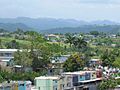
Morovis barrio-pueblo view from PR-155
-
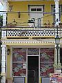
Store in Morovis barrio-pueblo
-
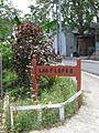
Las Flores neighborhood in barrio-pueblo
-
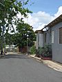
Morovis barrio-pueblo near José Fontán school
-
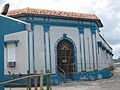
José Fontán School, listed on the National Register of Historic Places
-
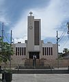
Catholic church in Morovis central plaza
-
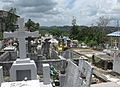
Municipal Cemetery of Morovis
-
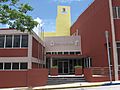
Town hall in Morovis Pueblo


See also
 In Spanish: Morovis (Morovis) para niños
- List of communities in Puerto Rico
- List of barrios and sectors of Morovis, Puerto Rico
