Morrow, Georgia facts for kids
Quick facts for kids
Morrow, Georgia
|
|||
|---|---|---|---|

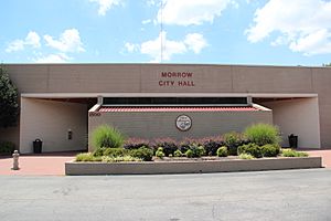
Morrow city hall
|
|||
|
|||
| Motto(s):
Come to Morrow
|
|||

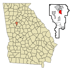
Location in Clayton County and the state of Georgia
|
|||
| Country | United States | ||
| State | Georgia | ||
| County | Clayton | ||
| Area | |||
| • Total | 3.39 sq mi (8.79 km2) | ||
| • Land | 3.38 sq mi (8.76 km2) | ||
| • Water | 0.01 sq mi (0.03 km2) | ||
| Elevation | 922 ft (281 m) | ||
| Population
(2020)
|
|||
| • Total | 6,569 | ||
| • Density | 1,942.34/sq mi (749.88/km2) | ||
| Time zone | UTC-5 (Eastern (EST)) | ||
| • Summer (DST) | UTC-4 (EDT) | ||
| ZIP codes |
30260, 30287
|
||
| Area code(s) | 770 | ||
| FIPS code | 13-53004 | ||
| GNIS feature ID | 0332423 | ||
Morrow is a city located in Clayton County, Georgia, United States. It is part of the larger Atlanta metropolitan area. In 2020, about 6,569 people lived here. Morrow is known for being home to Clayton State University and the Georgia Archives.
Contents
History of Morrow
Morrow was named after Radford E. Morrow. He was the first owner of the land where the city now stands. The community officially started in 1846. This happened when a railroad was built through the area. Morrow became an official city in 1943.
Geography and Location
Morrow is in the northern part of Clayton County. It is located at coordinates 33°34′43″N 84°20′24″W. To the north, it borders Lake City. To the northwest, it borders Forest Park.
Downtown Atlanta is about 13 miles (21 km) north of Morrow. Interstate 75 runs through the southern part of the city. You can get to Morrow from Exit 233 on I-75. The Southlake Mall is also in the southwest part of the city, close to I-75.
Size of the City
The United States Census Bureau says Morrow covers a total area of about 3.4 square miles (8.8 square kilometers). A very small part of this area, about 0.01 square miles (0.03 square kilometers), is water.
Population and People
Morrow has grown quite a bit over the years. In 1950, only 326 people lived here. By 2020, the population had grown to 6,569 people.
| Historical population | |||
|---|---|---|---|
| Census | Pop. | %± | |
| 1950 | 326 | — | |
| 1960 | 580 | 77.9% | |
| 1970 | 3,708 | 539.3% | |
| 1980 | 3,791 | 2.2% | |
| 1990 | 5,168 | 36.3% | |
| 2000 | 4,882 | −5.5% | |
| 2010 | 6,445 | 32.0% | |
| 2020 | 6,569 | 1.9% | |
| U.S. Decennial Census | |||
The city is home to a diverse group of people. In 2020, there were 2,046 households in Morrow. About 1,482 of these were families.
Education in Morrow
Public schools in Morrow are managed by Clayton County Public Schools. This school system helps educate many students in the area.
Morrow is also home to an important national building. The National Archives at Atlanta is located here. This is where many important historical documents are kept safe.
Getting Around Morrow
Morrow has several ways to get around, including major roads and public transportation.
Main Roads and Highways
Several important roads pass through Morrow:
![]() Interstate 75 is a major highway that goes through the southern part of the city. You can easily get onto I-75 from Exit 233, which connects to GA 54.
Interstate 75 is a major highway that goes through the southern part of the city. You can easily get onto I-75 from Exit 233, which connects to GA 54.
Public Transportation
Morrow is served by the MARTA bus system. These buses help people travel within the city and to other areas. There are three main bus routes:
- Route 193 - This route connects to the East Point Station.
- Route 194 - This route also connects to the East Point Station.
- Route 196 - This route connects to the College Park Station.
See also
- In Spanish: Morrow (Georgia) para niños


