Taymouth Township, Michigan facts for kids
Quick facts for kids
Taymouth Township, Michigan
|
|
|---|---|

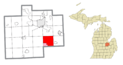
Location within Saginaw County (red) and the administered community of Burt (pink)
|
|
| Country | United States |
| State | Michigan |
| County | Saginaw |
| Area | |
| • Total | 35.7 sq mi (92.4 km2) |
| • Land | 35.6 sq mi (92.1 km2) |
| • Water | 0.1 sq mi (0.3 km2) |
| Elevation | 614 ft (187 m) |
| Population
(2020)
|
|
| • Total | 4,065 |
| • Density | 113.87/sq mi (43.994/km2) |
| Time zone | UTC-5 (Eastern (EST)) |
| • Summer (DST) | UTC-4 (EDT) |
| ZIP code(s) | |
| Area code(s) | 989 |
| FIPS code | 26-79100 |
| GNIS feature ID | 1627154 |
Taymouth Township is a special kind of local government area called a civil township. It is located in Saginaw County, which is part of the U.S. state of Michigan. In 2020, about 4,065 people lived here.
Contents
Exploring Taymouth Township Communities
Taymouth Township is home to several smaller communities. These places are often called unincorporated communities. This means they are not officially separate towns or cities. Instead, they are part of the larger township.
Discovering Burt, Michigan
- Burt is one of these unincorporated communities. It is also a census-designated place (CDP). This means the government counts its population separately for statistics.
Learning About Fosters
- Fosters is another unincorporated community. It is located between two parts of Busch Road. You can find it west of the Huron & Eastern Railway and Dorwood Road. The main streets here include Saginaw Street, Fosters Road, Railroad Street, Hasting Street, and Washington Street.
Visiting Morseville and Its Bridge
- Morseville is an unincorporated community found at the intersection of Morseville and Burt Roads. A very important landmark here is the Morseville Bridge. This bridge crosses the Flint River. It is so special that it is listed on the National Register of Historic Places. This means it is a historic site worth protecting.
Understanding Taymouth Community History
- Taymouth is also an unincorporated community within the township. It is located at 43°14′34″N 83°52′26″W / 43.24278°N 83.87389°W. This spot is on Seymour Road, between Birch Run and Burt Roads. A long time ago, from 1858 to 1903, Taymouth even had its own post office.
Geography of Taymouth Township
Taymouth Township covers a certain amount of land and water. The United States Census Bureau collects this information.
How Big Is Taymouth Township?
The total area of the township is about 35.7 square miles (92 km2). Most of this area is land.
Land and Water Areas
About 35.6 square miles (92 km2) of the township is land. The remaining part, about 0.1 square miles (0.26 km2), is water. This means only a small portion, about 0.34%, is covered by water.
Population and People of Taymouth Township
Understanding the people who live in Taymouth Township helps us learn about the community. This information comes from official counts, like the census.
Population Numbers Over Time
In the year 2000, there were 4,624 people living in the township. This number changed to 4,065 people by the 2020 Census.
Households and Families
In 2000, there were 1,583 households in Taymouth Township. A household is a group of people living together in one home. Out of these, 1,296 were families. Many households, about 39.7%, had children under 18 living with them.
Age Groups in the Township
The population of Taymouth Township includes people of all ages. In 2000, about 28.2% of the people were under 18 years old. About 8.1% were 65 years old or older. The median age was 35 years. This means half the people were younger than 35 and half were older.
See also
 In Spanish: Municipio de Taymouth para niños


