Moundville, Missouri facts for kids
Quick facts for kids
Moundville, Missouri
|
|
|---|---|

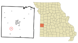
Location of Moundville, Missouri
|
|
| Country | United States |
| State | Missouri |
| County | Vernon |
| Area | |
| • Total | 0.16 sq mi (0.42 km2) |
| • Land | 0.16 sq mi (0.42 km2) |
| • Water | 0.00 sq mi (0.00 km2) |
| Elevation | 856 ft (261 m) |
| Population
(2020)
|
|
| • Total | 78 |
| • Density | 481.48/sq mi (185.82/km2) |
| Time zone | UTC-6 (Central (CST)) |
| • Summer (DST) | UTC-5 (CDT) |
| ZIP code |
64771
|
| Area code(s) | 417 |
| FIPS code | 29-50330 |
| GNIS feature ID | 2396785 |
Moundville is a small village located in the southwestern part of Vernon County, Missouri, in the United States. In 2010, the village had 124 people living there. By 2020, the population was 78.
Contents
A Look Back in Time
Moundville was first planned out and mapped in 1869. This process is called platting. The village got its name because of a natural mound, which is like a small hill, located near where the town was first built.
A post office was opened in 1870 and was first called Mounds. Later, in 1886, its name was changed to Moundville, matching the village's name.
Where is Moundville?
Moundville is found along Missouri Route 43. It is about 4.5 miles north of Bronaugh. It is also about six miles southwest of Nevada.
The United States Census Bureau reports that the village covers a total area of about 0.16 square miles (0.42 square kilometers). All of this area is land, with no water.
People of Moundville
The population of Moundville has changed over the years. Here is a quick look at how many people have lived there during different census counts:
| Historical population | |||
|---|---|---|---|
| Census | Pop. | %± | |
| 1880 | 85 | — | |
| 1890 | 219 | 157.6% | |
| 1900 | 287 | 31.1% | |
| 1910 | 247 | −13.9% | |
| 1920 | 240 | −2.8% | |
| 1930 | 243 | 1.3% | |
| 1940 | 247 | 1.6% | |
| 1950 | 168 | −32.0% | |
| 1960 | 136 | −19.0% | |
| 1970 | 149 | 9.6% | |
| 1980 | 149 | 0.0% | |
| 1990 | 140 | −6.0% | |
| 2000 | 103 | −26.4% | |
| 2010 | 124 | 20.4% | |
| 2020 | 78 | −37.1% | |
| U.S. Decennial Census | |||
A Snapshot from 2010
In 2010, the census showed that 124 people lived in Moundville. There were 49 households, and 35 of these were families. The village had about 775 people per square mile.
Out of the 49 households, about 32.7% had children under 18 living with them. More than half, 55.1%, were married couples living together. About 22.4% of all households were made up of people living alone. Roughly 10.2% of households had someone aged 65 or older living by themselves.
The average age of people in the village was 40 years old. About 24.2% of the residents were under 18. Around 17.7% were 65 years old or older. The population was 54.0% male and 46.0% female.
See also
 In Spanish: Moundville (Misuri) para niños
 | Madam C. J. Walker |
 | Janet Emerson Bashen |
 | Annie Turnbo Malone |
 | Maggie L. Walker |

