
Mount Chiginagak facts for kids
Quick facts for kids Mount Chiginagak |
|
|---|---|

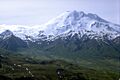
View, looking southeast, of Chiginagak volcano
|
|
| Highest point | |
| Elevation | 7,287 ft (2,221 m) |
| Prominence | 6,675 ft (2,035 m) |
| Listing |
|
| Geography | |

Mount Chiginagak
Location in Alaska
|
|
| Location | Alaska Peninsula National Wildlife Refuge, Lake and Peninsula Borough, Alaska |
| Parent range | Aleutian Range |
| Topo map | USGS Ugashik A-3 |
| Geology | |
| Mountain type | Stratovolcano |
| Volcanic arc/belt | Aleutian Arc |
| Last eruption | August 1998 |
Mount Chiginagak is a stratovolcano (a cone-shaped volcano built up by many layers of hardened lava and ash) located on the Alaska Peninsula. It sits about 15 kilometers (9 miles) northwest of Chiginagak Bay. This volcano is part of the Aleutian Range, a long chain of mountains and volcanoes in Alaska.
Volcano Activity
Chiginagak has shown signs of activity over the years. The most recent lava flows and ash deposits came from a lava dome (a round, steep-sided mound formed by slow-moving lava) on its southeast side. This dome is about 1 kilometer (0.6 miles) from the volcano's top.
Small ash eruptions were reported in July 1971 and again in August 1998. Even when not erupting, the volcano has active spots. Hot gases and steam, called fumaroles, come out from the northeast side of the volcano at about 1600 meters (5,250 feet) high. There are also hot springs at the base of the volcano near Volcano Creek.
The Acidic Lake Event
Between late 2004 and early 2005, a crater lake formed at the very top of Chiginagak. This lake was about 400 meters (1,300 feet) wide and 105 meters (344 feet) deep. The water in this lake became very acidic.
In May 2005, something big happened. The acidic water from the lake suddenly burst out. This flood of acidic water, along with acidic mist, rushed down the mountain. It flowed into nearby creeks, like Indecision Creek and Volcano Creek. The acidic water traveled about 27 kilometers (17 miles) downstream. It eventually reached Mother Goose Lake, which is where the King Salmon River begins.
Environmental Impact
The acidic flood caused a lot of damage. Plants along the flood path were badly harmed. Mother Goose Lake became very acidic, with a pH of 2.9-3.1. (A pH of 7 is neutral; lower numbers mean more acidic.) This high acidity killed all the fish and other water creatures in the lake. It also stopped the yearly salmon run, which is when salmon swim upstream to lay their eggs.
Today, the lake at the summit drains through a cave into Indecision Creek. This creek often smells strongly of sulfur and has a yellow color. Its pH is usually around 1.3, making it extremely acidic.

Images for kids
-
View, looking southeast, of Chiginagak volcano
See also
 In Spanish: Monte Chiginagak para niños
