
Mount Gould (Montana) facts for kids
Quick facts for kids Mount Gould |
|
|---|---|

Mount Gould with eastern cliff face
|
|
| Highest point | |
| Elevation | 9,557 ft (2,913 m) |
| Prominence | 1,953 ft (595 m) |
| Parent peak | Mount Siyeh |
| Listing | Mountains in Glacier County, Montana |
| Geography | |

Mount Gould
Location in Montana
|
|
| Parent range | Lewis Range |
| Topo map | USGS Logan Pass |
| Climbing | |
| First ascent | 1920 by Frank B. Wynn, Harry R. Horn, Henry H. Goddard, and party |
| Easiest route | West Face (scramble/Class 3) |
Mount Gould is a tall mountain peak in Glacier National Park, Montana, United States. It stands at 9,557 feet (2,913 meters) high. This mountain is part of the Continental Divide. This is a line of high ground that separates rivers flowing to the Pacific Ocean from those flowing to the Atlantic Ocean.
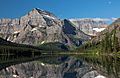
Mount Gould is the highest point of a special ridge called the Garden Wall. This ridge is part of the Lewis Range of mountains. The mountain is famous for its huge, steep east side. This side drops about 4,000 feet (1,200 meters) in just half a mile. This dramatic cliff face is a beautiful background for Grinnell Lake and is often photographed.
Exploring Mount Gould
The first time people officially climbed Mount Gould was in 1920. A group led by Frank B. Wynn, Harry R. Horn, and Henry H. Goddard made the climb. They used the West Face route. This is still the easiest and most common way to reach the top today.
The West Face Route
The West Face route starts from the Highline Trail. This trail goes along the western side of the mountain. The climb involves some rock scrambling. Scrambling means climbing over rocks using both your hands and feet, but it's not as difficult as technical rock climbing. You don't need special ropes or gear for this route.
The East Face Challenge
Climbing the very steep East Face of Mount Gould is much harder. The rocks in Glacier National Park are often brittle and loose. This makes climbing very difficult and dangerous. It requires special climbing skills and equipment.

Images for kids
-
East face of Mount Gould and Angel Wing above Lake Josephine

