Mount Hurd facts for kids
Quick facts for kids Mount Hurd |
|
|---|---|

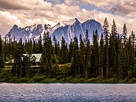
Mt. Vaux centered with Mt. Hurd furthest right in this view from Emerald Lake
|
|
| Highest point | |
| Elevation | 3,000 m (9,800 ft) |
| Prominence | 355 m (1,165 ft) |
| Parent peak | Mount Vaux |
| Geography | |
| Location | Yoho National Park British Columbia, Canada |
| Parent range | Canadian Rockies |
| Topo map | NTS 82N07 |
Mount Hurd is a tall mountain in the Canadian Rockies, located in British Columbia, Canada. It is part of the Ottertail Range. This mountain was named after Marshall Farnam Hurd, an engineer and explorer who worked for the Canadian Pacific Railway. Mount Hurd is quite famous; it even appeared on a Canadian postage stamp in 1928! The stamp featured a painting of the mountain by Frederic Marlett Bell-Smith.
What is the Climate Like on Mount Hurd?
Mount Hurd has a subarctic climate. This means it has very cold, snowy winters and mild summers. During winter, temperatures can drop below −20 °C (that's −4 °F). With the wind, it can feel even colder, sometimes below −30 °C (−22 °F).
Where Does the Water Go?
All the rain and melting snow from Mount Hurd flows into small streams. These streams eventually join the Kicking Horse River. The Kicking Horse River is a larger river that flows into the Columbia River.
Where is Mount Hurd Located?
Mount Hurd is found within Yoho National Park in British Columbia. This park is known for its amazing mountains, waterfalls, and lakes. The mountain is part of the Canadian Rockies, a huge mountain range in North America.
 | Aaron Henry |
 | T. R. M. Howard |
 | Jesse Jackson |


