Mount Jefferson (Madison County, Montana) facts for kids
Quick facts for kids Mount Jefferson |
|
|---|---|

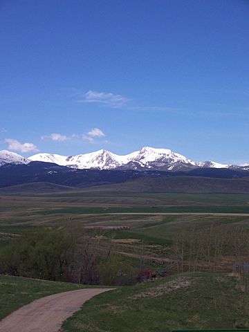
Mt Jefferson and Hollowtop
|
|
| Highest point | |
| Elevation | 10,513 ft (3,204 m) |
| Prominence | 393 ft (120 m) |
| Geography | |
| Parent range | Tobacco Root |
| Topo map | USGS Noble Peak, MT |
| Climbing | |
| Easiest route | Hike |
Mount Jefferson is a mountain in Montana, U.S.. It is one of many tall peaks in the Tobacco Root Mountains. You can find it in the Beaverhead-Deerlodge National Forest. There is also another Mount Jefferson in Montana, closer to the Idaho border.
Right next to Mount Jefferson, to the north, is Hollowtop Mountain. Hollowtop is a bit taller. For many years, these two mountains had different names and heights on maps. Today, maps from the U.S. Geological Survey show Mount Jefferson is about 10,513 feet (3,204 meters) tall. Hollowtop Mountain, to the north, is about 10,604 feet (3,232 meters) high.
What's in a Name?
The names for Mount Jefferson and Hollowtop Mountain have changed a lot over time. This has caused some confusion.
In 1914, a report by A.N. Winchell called the highest peak in the Tobacco Root Mountains "Jefferson Peak." People in the area often called it "Old Hollowtop." Since then, the taller peak to the north has usually been called Hollowtop. This name makes sense because of the bowl-shaped area at the top of Hollowtop peak.
Some older maps called the northern peak Mount Jefferson. It also caused confusion because a special survey marker (called JEFFERSON) is on the southern peak. This marker is found on many maps.
Over the years, different maps showed different names and heights for the two peaks:
- In 1933, some maps called the highest point Mount Jefferson.
- A 1937 map of the Gallatin National Forest labeled the northern peak Mount Jefferson. It gave it a height that was later found to be wrong. The southern peak was called Hollow Top Mountain.
- A 1938 map of the Deerlodge National Forest tried to use both names for the northern peak. The southern peak only had the JEFFERSON marker.
- In 1957, one map called the northern peak Mount Jefferson and the southern one Goat Mountain.
- By 1960, a map showed Mount Jefferson to the north and Hollowtop Mountain to the south. The U.S. Board on Geographic Names said this was the correct way in 1976.
Finally, in 1987, a map called the Interagency Visitors Map of Southwest Montana showed both names clearly. It labeled the northern peak Hollowtop Mountain and the southern peak Mount Jefferson. This was the first map to show both names this way.
The 1989 Noble Peak map also shows Hollowtop Mountain (10,604 feet) to the north. Mount Jefferson (10,513 feet) is to the south. Today, most maps agree with these names and heights.
Mountain Rocks
Most of Mount Jefferson is made of a type of rock called granite. This granite formed about 75 million years ago during the Late Cretaceous Period. This large body of granite is known as the Tobacco Root Batholith. A batholith is a very large mass of igneous rock that forms when molten rock (magma) cools and hardens deep within the Earth's crust.
Some parts of Mount Jefferson and Hollowtop Mountain also have older metamorphic rocks. These rocks are from the Archean time, which was billions of years ago.
When the granite formed, it also created valuable minerals along cracks in the rocks.
- The Mammoth Mine, north of Mount Jefferson, produced a lot of gold in the late 1800s and early 1900s.
- The Nicholson Gold Mine, on the west side of Mount Jefferson, was active in the 1990s.
The bowl-like shape at the top of Hollowtop Mountain is not a typical cirque. A cirque is a bowl-shaped hollow carved by a glacier. While snow and ice were likely there during the ice age, it doesn't show the deep marks of a moving glacier.
 | George Robert Carruthers |
 | Patricia Bath |
 | Jan Ernst Matzeliger |
 | Alexander Miles |


