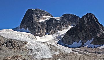
Mount Monica facts for kids
Quick facts for kids Mount Monica |
|
|---|---|

Mount Monica, north aspect
|
|
| Highest point | |
| Elevation | 3,072 m (10,079 ft) |
| Prominence | 392 m (1,286 ft) |
| Parent peak | Jumbo Mountain (3437 m) |
| Geography | |
| Location | British Columbia, Canada |
| Parent range | Purcell Mountains |
| Topo map | NTS 82K/7 |
| Climbing | |
| First ascent | 1911 Coffin, Harnden, Poorman |
| Easiest route | class 3 Southeast Ridge |
Mount Monica is a tall mountain in the Purcell Mountains of southeastern British Columbia, Canada. It stands 3,072-metre (10,079-foot) high, which is like stacking over 10 Eiffel Towers! This impressive peak is located 56 km (35 mi) north of Kaslo and 48 km (30 mi) west of Invermere. The closest taller mountain is Jumbo Mountain, about 9 km (5.6 mi) to the east.
The very first ascent of Mount Monica happened in August 1911. A team of climbers, E. W. Harnden, M. Coffin, and J. Poorman, reached the top using the southeast ridge. Edward Warren Harnden named the mountain after his mother, Monica. The name was officially recognized on June 9, 1960, by the Geographical Names Board of Canada.
Mountain Weather: Mount Monica's Climate
Mount Monica is in a subarctic climate zone. This means it has very cold and snowy winters, but its summers are mild. Temperatures can drop below −20 °C, and with the wind, it can feel even colder, sometimes below −30 °C!
Water from the mountain, including rain and meltwater from nearby glaciers, flows in two main directions. To the west, it drains into Glacier Creek, which then joins the Duncan River. To the east, the water flows into Horsethief Creek, which is part of the Columbia River.
Reaching the Top: Climbing Routes
Mount Monica offers exciting challenges for climbers. There are two main ways to climb to its summit. These routes are rated using the Yosemite Decimal System (YDS), which tells climbers how difficult a route is.
 | Selma Burke |
 | Pauline Powell Burns |
 | Frederick J. Brown |
 | Robert Blackburn |


