Mount Morfee facts for kids
Quick facts for kids Mount Morfee |
|
|---|---|
| Morfee Mountain | |

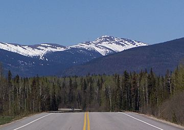
Mount Morfee from Highway 39
|
|
| Highest point | |
| Elevation | 1,775 m (5,823 ft) |
| Prominence | 521 m (1,709 ft) |
| Parent peak | Mount Murray |
| Geography | |
| Parent range | Misinchinka Ranges |
| Topo map | NTS 93O/06 |
Mount Morfee is a tall mountain in British Columbia, Canada. It stands 1,775 metres (5,823 feet) high. This peak is part of the Misinchinka Ranges, which are a smaller part of the Hart Ranges. These ranges are found within the larger Northern Rocky Mountains.
Locally, people often call it Morfee Mountain. It is a very noticeable landmark near the town of Mackenzie, BC.
Contents
How Mount Morfee Got Its Name
Mount Morfee was named after a brave pilot named Flight Lieutenant Alan Morfee. He was part of the Royal Canadian Air Force. In the early 1930s, he flew over this area. He took some of the very first aerial photos of the region.
Because of his important work, several places are named after him. These include the nearby Morfee Lake and Morfee Creek. There is also an island near Tofino, BC, that shares his name.
Fun Activities on Morfee Mountain
Mount Morfee is easy to get to, thanks to Highway 39. This makes it a popular spot for outdoor fun.
Winter Adventures
During the winter, the mountain is a favorite place for snowmobiling. People love to ride their snowmobiles across its snowy slopes.
Summer Explorations
In the summer, a gravel road goes all the way to the top. This road makes it easy for people to go biking and hiking. It's a great way to explore the mountain and enjoy nature.
 | Selma Burke |
 | Pauline Powell Burns |
 | Frederick J. Brown |
 | Robert Blackburn |


