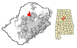
Mount Olive, Jefferson County, Alabama facts for kids
Quick facts for kids
Mount Olive, Alabama
|
|
|---|---|

Location in Jefferson County and the state of Alabama
|
|
| Country | United States |
| State | Alabama |
| County | Jefferson |
| Area | |
| • Total | 9.30 sq mi (24.09 km2) |
| • Land | 9.30 sq mi (24.08 km2) |
| • Water | 0.01 sq mi (0.01 km2) |
| Elevation | 607 ft (185 m) |
| Population
(2020)
|
|
| • Total | 4,427 |
| • Density | 476.18/sq mi (183.85/km2) |
| Time zone | UTC-6 (Central (CST)) |
| • Summer (DST) | UTC-5 (CDT) |
| ZIP code |
35117
|
| Area code(s) | 205, 659 |
| FIPS code | 01-52344 |
| GNIS feature ID | 0123277 |
Mount Olive, also known as Mt. Olive, is a community in Jefferson County, Alabama. It's a place where people live, but it doesn't have its own city government. It's also called a census-designated place (CDP), which means it's an area the U.S. Census Bureau defines for gathering population data.
Mount Olive is located just outside of Birmingham, a larger city. In 2020, about 4,427 people lived there. It shares borders with the town of Gardendale. Over the years, some parts of Mount Olive have become part of Gardendale. A major highway, Interstate 65, runs along part of the border between Mount Olive and Gardendale.
Mount Olive has its own elementary school. It used to have a junior high school too.
Contents
Where is Mount Olive Located?
Mount Olive is found at 33°41′3″N 86°52′31″W / 33.68417°N 86.87528°W.
The U.S. Census Bureau says the community covers about 9.3 square miles (24.1 square kilometers) of land. There is almost no water area within its borders.
How Many People Live in Mount Olive?
| Historical population | |||
|---|---|---|---|
| Census | Pop. | %± | |
| 2000 | 3,957 | — | |
| 2010 | 4,079 | 3.1% | |
| 2020 | 4,427 | 8.5% | |
| U.S. Decennial Census | |||
The U.S. Census Bureau counts the population of places like Mount Olive every ten years.
Population in 2020
| Race | Number of People | Percentage |
|---|---|---|
| White (not Hispanic) | 4,029 | 91.01% |
| Black or African American (not Hispanic) | 117 | 2.64% |
| Native American | 12 | 0.27% |
| Asian | 19 | 0.43% |
| Pacific Islander | 1 | 0.02% |
| Other/Mixed | 166 | 3.75% |
| Hispanic or Latino | 83 | 1.87% |
In 2020, there were 4,427 people living in Mount Olive. These people lived in 1,620 households, and 1,280 of these were families.
Population in 2010
According to the 2010 census, 4,079 people lived in Mount Olive. There were 1,551 households and 1,217 families. The population density was about 440 people per square mile (170 people per square kilometer).
Most of the people in Mount Olive were White (97.7%). A small percentage were Black or African American (1.0%), Native American (0.2%), or Asian (0.3%). About 0.5% of the population identified as Hispanic or Latino.
- About 30.4% of households had children under 18 living with them.
- Most households (66.9%) were married couples.
- About 19.2% of households were single people living alone.
- The average household had 2.63 people.
The median age in Mount Olive in 2010 was 41.7 years old. This means half the people were younger than 41.7 and half were older.
See also
 In Spanish: Mount Olive (condado de Jefferson) para niños
 | Chris Smalls |
 | Fred Hampton |
 | Ralph Abernathy |

