Mount Pavlof facts for kids
Quick facts for kids Mount Pavlof |
|
|---|---|

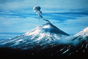
Steam and volcanic gas rising from the summit crater of Pavlof Volcano in 2004
|
|
| Highest point | |
| Elevation | 8,251 ft (2,515 m) |
| Prominence | 8,225 ft (2,507 m) |
| Listing |
|
| Geography | |
| Location | Alaska Peninsula, Alaska, U.S. |
| Parent range | Aleutian Range |
| Topo map | USGS Port Moller B-6 |
| Geology | |
| Age of rock | 252 |
| Mountain type | Stratovolcano |
| Volcanic arc/belt | Aleutian Arc |
| Last eruption | October 29 2019 (ongoing) |
| Climbing | |
| First ascent | June 27, 1928 by T. A. Jagger, J. Gardiner, O. P. McKinley, P. A. Yatchmenoff, R. H. Stewart |
| Easiest route | Northwest Face: snow/glacier climb |
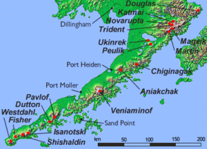
Pavlof Volcano is a tall, cone-shaped stratovolcano (a volcano built up by many layers of hardened lava, ash, and rocks) located on the Alaska Peninsula. It's part of the Aleutian Range.
Since 1980, Pavlof Volcano has been one of the most active volcanoes in the United States. It has erupted many times, including in 1980, 1981, 1983, 1986–1988, 1996–1997, 2007, 2013, twice in 2014, and most recently in March 2016. The most common type of lava it produces is called basaltic andesite.
Scientists from the Alaska Volcano Observatory keep a close eye on Pavlof. This observatory is a team effort by the United States Geological Survey (USGS), the University of Alaska Fairbanks, and the State of Alaska. Pavlof is considered a high-threat volcano. This is mainly because its eruptions can send large ash clouds high into the sky. These ash clouds can be dangerous for airplanes flying nearby. The volcano has some monitoring equipment, but the USGS wants to add even more tools to watch it better. Pavlof Volcano has a neighbor called Pavlof Sister, which last erupted a long time ago in 1786.
Contents
Pavlof Volcano's Eruptions
After an eruption in 1996, Pavlof Volcano went quiet for a while. This was the longest it had been dormant (inactive) since records began. But this quiet period ended on August 15, 2007. A new eruption started with shaking ground and a strong flow of lava.
Scientists warned that the volcano might be building up to a bigger eruption. This could affect air travel, but it was not expected to harm any nearby towns. The eruption finished on September 13, 2007.
Recent Eruptions and Ash Clouds
The volcano erupted again on May 13, 2013. Its activity slowly decreased, and by August 8, 2013, the alert level was lowered to "NORMAL." This meant the volcano was quiet again.
Another small eruption began on May 31, 2014. On June 2, the ground shaking became stronger. Officials raised the alert level to "Warning" and the aviation color code to "Red." This happened after pilots saw an ash cloud reaching about 22,000 feet (6,700 meters) high.
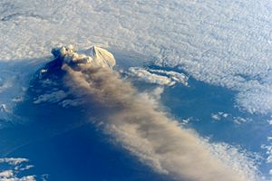
A new eruption started on March 27, 2016. This time, it sent an ash cloud soaring to 37,000 feet (11,300 meters) above sea level. The cloud stretched for 400 miles (640 kilometers) to the northeast. The volcano gave only 25 minutes of warning before this powerful eruption began. The alert level was quickly raised to "Warning" and the aviation color code to "Red." This indicates a strong eruption with a lot of ash. The nearby village of Nelson Lagoon was covered in tephra (volcanic rock fragments) during this eruption. The volcano stopped releasing ash clouds on March 31, 2016.
Climbing Pavlof Volcano
The first time someone officially climbed Pavlof Volcano was on June 27, 1928. The climbers were T. A. Jagger, J. Gardiner, O. P. McKinley, P. A. Yatchmenoff, and R. H. Stewart. People wonder if someone might have climbed it even earlier without it being recorded. This is because the climb itself is not extremely difficult. The second recorded climb happened in June 1950 by T. P. Bank.
The biggest challenge in climbing Pavlof Volcano is how far away it is. It's about 30 miles (48 kilometers) from the north side of Cold Bay. The actual climb is mostly over snow. Many climbers suggest skiing down the volcano after reaching the top.
See also
 In Spanish: Monte Pavlof para niños
 | Bessie Coleman |
 | Spann Watson |
 | Jill E. Brown |
 | Sherman W. White |


