Mount Pinacle facts for kids
Quick facts for kids Mount Pinacle |
|
|---|---|
| Le Pinacle | |

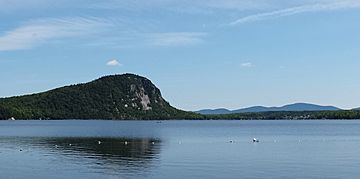
View of the Mount Pinacle, Baldwin Mill's
|
|
| Highest point | |
| Elevation | 665 m (2,182 ft) |
| Prominence | 120 m (390 ft) |
| Isolation | 2.49 km (1.55 mi) |
| Geography | |
| Parent range | Northern Appalachians |
| Topo map | NTS: 21E/04 |
| Climbing | |
| Easiest route | hiking, rock climbing |
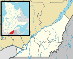
Mount Pinacle (also known as Le Pinacle in French) is a mountain in Coaticook, Quebec, Canada. It's a great place for outdoor adventures!
You can explore the mountain on its many trails. There are about 7.8 kilometers (4.8 miles) of paths for hikers to enjoy for free. If you're an experienced rock climber, you can even climb up the side of the mountain from Lake Lyster.
Mount Pinacle is also known for its many maple trees. A "sugar bush" operates here, which means people collect sap from the maple trees to make delicious maple syrup!
History of Mount Pinacle
The mountain has been officially called Le Pinacle since 1978. This name helps people identify it clearly.
Protecting Wildlife
In 2013, a part of Mount Pinacle was temporarily closed to rock climbing. This was done to protect peregrine falcons. These amazing birds were nesting on the mountain, and the closure helped keep their babies safe. It's important to protect wildlife and their homes!
Mountain Safety
In June 2014, a 10-year-old child had an accident during a field trip on the mountain. They fell about 10 meters (33 feet) into a crevice. Luckily, many firefighters quickly came to help. About a dozen firefighters worked for two hours to rescue the child. The child was not seriously hurt, which was a great relief. This event reminds us to always be careful and aware of our surroundings when exploring nature.
 | John T. Biggers |
 | Thomas Blackshear |
 | Mark Bradford |
 | Beverly Buchanan |


