
Mount Pleasant, Western Australia facts for kids
Quick facts for kids Mount PleasantPerth, Western Australia |
|||||||||||||||
|---|---|---|---|---|---|---|---|---|---|---|---|---|---|---|---|

Blue Gum Lake, Mount Pleasant
|
|||||||||||||||
| Established | 1911 | ||||||||||||||
| Postcode(s) | 6153 | ||||||||||||||
| LGA(s) | City of Melville | ||||||||||||||
| State electorate(s) | Bateman and Riverton | ||||||||||||||
| Federal Division(s) | Tangney | ||||||||||||||
|
|||||||||||||||
Mount Pleasant is a friendly suburb in Perth, Western Australia. It's located on the beautiful Canning River. This area is part of the traditional lands of the Wajuk people.
Mount Pleasant is part of the City of Melville. It is bordered by Canning Highway to the north and the Canning River to the east. You can find Mount Pleasant Primary School right in the middle of the suburb. Brentwood Primary School is also very close, just south of Blue Gum Park.
Getting Around Mount Pleasant
Mount Pleasant is easy to get to and from, thanks to its public transport options. Buses are a great way for people to travel around the suburb and to other parts of Perth.
Bus Routes Serving Mount Pleasant
Several bus routes pass through Mount Pleasant. They connect the suburb to important places like train stations and city centers.
- Route 111: This bus travels from the WACA Ground all the way to Fremantle Station. It uses Canning Highway.
- Route 114: You can take this bus from Elizabeth Quay Bus Station to Lake Coogee. It also runs along Canning Highway.
- Route 115: This route goes from Elizabeth Quay Bus Station to Hamilton Hill Memorial Hall. It serves Canning Highway.
- Route 160: This bus connects the WACA Ground to Fremantle Station. It uses Canning Highway, Reynolds Road, and Coomoora Road.
- Route 500: This route runs between Booragoon Bus Station and Bull Creek Station. It travels along Canning Avenue and Bateman Road.
- Route 910: This is a very frequent bus service. It goes from Perth Busport to Fremantle Station and uses Canning Highway.
Images for kids
-
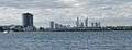
Canning Bridge and Perth CBD as viewed from Mount Pleasant
-
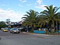
Queens Road shopping precinct
-
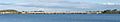
Mount Henry Bridge, taken from Deep Water Point

