Mount Sentinel facts for kids
Quick facts for kids Mount Sentinel |
|
|---|---|

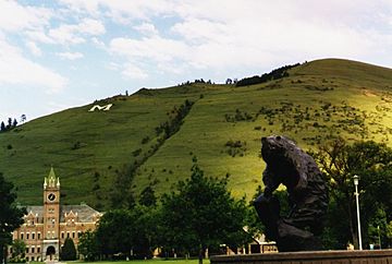
Mount Sentinel with University of Montana Campus in the foreground.
|
|
| Highest point | |
| Elevation | 5,158 ft (1,572 m) |
| Prominence | 118 ft (36 m) |
| Geography | |
| Parent range | Sapphire Mountains |
| Topo map | USGS Southeast Missoula |
Mount Sentinel is a cool mountain right next to the University of Montana in Missoula. It was once called "Mount Woody." This mountain stands 5,158 feet (1,572 meters) tall.
A famous part of Mount Sentinel is the giant concrete letter "M". This huge "M" is a hillside letter that sits 620 feet (189 meters) up its western side. It's a symbol for the university and the city.
Contents
Mount Sentinel's Story
The University of Montana got its first piece of land on Mount Sentinel in 1902. The Northern Pacific Railroad Company gave 40 acres at the bottom and up the side of the mountain. Later, the U.S. Congress gave even more land. This meant the university owned land all the way to the top of the mountain! It's the only university in the country to own a whole mountain. In 2000, the city of Missoula also bought 475 acres on the mountain's face.
Ancient Glacial Lake Missoula
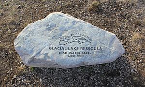
A very long time ago, between 15,000 and 13,000 years ago, a huge glacier moved through northern Idaho. This glacier blocked the Clark Fork River. It created an enormous body of water called Glacial Lake Missoula. This ancient lake was bigger than both Lake Erie and Lake Ontario put together!
As the lake grew, the pressure on the ice dam became too much. Eventually, the dam broke. Water from the lake rushed out at amazing speeds, between 30 and 50 miles per hour. It flowed across Montana, Idaho, and Washington. This powerful flood left marks on the side of Mount Sentinel. You can still see these old shoreline marks today. They are also visible on Mount Jumbo, a nearby mountain.
The Famous "M" on the Mountain
How the "M" Was Built
The very first path up Mount Sentinel to where the "M" is now was made in 1908. Forestry students from the university cut this trail. In 1909, the junior class built the first "M" using whitewashed rocks.
A few years later, in 1912, the freshman class built a small wooden "M". It stood upright on the mountain and cost $18 to make. But strong winds destroyed this wooden "M" in 1914. It was replaced, but then wind wrecked it again. So, in 1915, a new "M" made of whitewashed rocks was built. This one was placed 200 feet higher than the first "M" site.
The "M" you see today is made of concrete. It was built in 1968 and measures 125 feet by 100 feet. This concrete "M" cost $4,328 to build. It was made because it was too hard to keep fixing the old rock "M".
Fun Traditions with the "M"
For many years, from 1915 to 1968, the "M" was made of rocks. Each year, freshman boys would hike up the trail. Their job was to paint the rocks with a fresh coat of white-wash. This tradition stopped when the concrete "M" was built.
Another tradition started in 1919. Freshman boys would hike to the "M" during homecoming celebrations. They would light up its outline with railroad lanterns. This tradition is still alive today! Now, UM Advocates make the hike each year to light the "M" during homecoming.
Also, every year during Native American Awareness Week, a special sunrise ceremony happens at the base of the "M". People gather to sing traditional Salish Morning and Honor Songs.
Keeping Mount Sentinel Healthy
People work hard to take care of Mount Sentinel. The University of Montana has a natural areas weed manager. This person organizes a yearly plan to remove unwanted plants using special sprays. There's also a community event each year where volunteers help pull weeds from the mountain. The Forest Service also helps control weeds on the 441 acres of Mount Sentinel that they own.
In 2006, a company called REI gave a $10,000 grant. This money went to Friends of Missoula Parks to help improve Mount Sentinel. REI gives grants to groups that protect community parks.
After a fire in 2008, experts worked together to help the mountain heal. The conservation lands manager for Missoula and a university specialist spread native grass and flower seeds. They planted them over the areas of Mount Sentinel that had burned.
In the fall of 2010, students from the University of Montana helped restore the "M" trail. They worked with Run Wild Missoula and other volunteers. The group added gravel to the path and planted seeds in bare spots. They also blocked unwanted side trails and added more steps to a part of the trail.
Making a Difference on Mount Sentinel
Mount Sentinel has also been a place for people to share important messages.
In 2005, students from Missoula's Hellgate High School placed a large red ribbon next to the "M". This ribbon was 50 feet by 20 feet. It was part of their annual Red Ribbon Week. This event teaches students about staying drug-free.
In 2010, environmental activists put up a white "350" made of tarps next to the "M". This display was part of a worldwide effort by the 350.org organization. Over 7,000 groups around the world did projects to help slow down climate change. They wanted to make people more aware of the issue.
Fires on Mount Sentinel
Mount Sentinel has had many fires over the years. The first recorded grass fire was in 1930.
More recently, in July 2008, a fire burned over 300 acres. This was on the west side of Mount Sentinel, right above the University of Montana campus.
Another fire in July 2006 burned at least 20 acres.
On August 20, 2020, a 25-acre grass fire started on the west face. It was caused by two children playing with a lighter.
Explore the Trails
Mount Sentinel has many trails for hiking and walking.
- The Kim Williams Nature Trail runs along the Clark Fork River. This is at the bottom of Mount Sentinel.
- The Hellgate Canyon Trail starts at the Kim Williams Nature Trail. It goes all the way to the top of the mountain.
- The Mo Z Trail begins from Pattee Canyon Road. It also starts near the UM Golf Course. This trail leads up to the Sentinel Fire Road and Pengelly Ridge Trail.
- The Pengelly Ridge Trail continues from the Mo Z Trail. It goes up to the very peak of Mount Sentinel.
- The Crooked Trail starts at the end of the Mo Z Trail. It goes east along the back side of the mountain.
- The "M" Trail is a special path with switchbacks. It starts at the University of Montana campus. This trail leads directly up to the famous "M".
- The Sentinel Fire Road is also a popular path. The city of Missoula owns it, and everyone can use it. This road runs from the end of the Mo Z Trail up to the "M".
Plants and Animals of Mount Sentinel
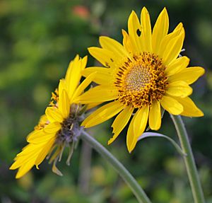
Even though parts of Mount Sentinel look bare, it has many interesting plants. You can find bitterroot plants, balsam root, paintbrush, and prairie smoke. There are also penstemons, Ponderosa pine trees, and Douglas fir trees. However, some unwanted plants, called invasive weeds, also grow there. These include knapweed, cheatgrass, leafy spurge, and Dalmatian toadflax.
The mountain is also home to various animals. You might see whitetail deer and mule deer. Falcons fly in the sky above. Sometimes, even black bears visit the mountain.
 | DeHart Hubbard |
 | Wilma Rudolph |
 | Jesse Owens |
 | Jackie Joyner-Kersee |
 | Major Taylor |


