
Mount Sugarloaf (New South Wales) facts for kids
Quick facts for kids Mount Sugarloaf |
|
|---|---|
| Great Sugar Loaf | |

Mount Sugarloaf viewed from West Wallsend
|
|
| Highest point | |
| Elevation | 412 m (1,352 ft) |
| Geography | |

Mount Sugarloaf
Location in New South Wales
|
|
| Location | Hunter Region, New South Wales, Australia |
| Parent range | Sugarloaf Range |
| Topo map | NEWCASTLE 9232, WALLSEND 92323S |
| Climbing | |
| Easiest route | Road to carpark at 370 m (1,214 ft), walking track to summit |
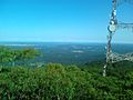
Mount Sugarloaf, also known as Great Sugar Loaf, is a mountain in the Hunter Region of New South Wales, Australia. It stands 412 metres (1,352 feet) tall. From its top, you can see the cities of Newcastle, Lake Macquarie, Cessnock, and Maitland.
The very top of Mount Sugarloaf is in the suburb of West Wallsend, which is part of Lake Macquarie. You can reach the summit by driving through this suburb. However, the mountain also stretches into the Cessnock suburbs of Mulbring and Richmond Vale. Mount Sugarloaf is important because it has towers that send out television signals to the local area. It even snowed on the mountain in July 1965 and again in the winter of 1975!
Contents
Television Transmitters
Mount Sugarloaf is home to two large towers that send out television signals. These towers have been broadcasting TV since the 1960s.
How TV Signals Work
For a long time, these towers sent out analogue television signals. In 2012, these older signals were turned off. Now, the towers send out digital television signals. All digital TV in the lower Hunter area uses a special type of signal called UHF.
The NBN Tower
One of the towers is often called the "NBN Tower." It was built to send out signals for NBN Television. Today, this tower broadcasts NBN and two government digital TV channels.
Broadcast Australia Tower
The second tower sends out signals for the other two main commercial digital TV stations. This tower is managed by a company called Broadcast Australia. Besides TV, both towers also have many other antennas. These are used for radio stations like 105.3 NEWFM and for amateur radio (ham radio) groups.
Smaller Communication Tower
There is also a third, smaller tower on Mount Sugarloaf. This tower has many antennas that point in different directions. It is mainly used for telecommunications, which means sending phone and internet signals. It also helps with two-way radios for emergency services and other important groups. You might see "Telstra" written on some of the equipment there.
Aboriginal History of Warrawelong

The Awabakal people, who are the traditional owners of this land, call the mountain Warrawelong. It is a very special place for them. From the top of Warrawelong, the Awabakal people could see all their lands. It was an important place for teaching and learning. Sacred ceremonies were also held there.
The shape of the mountain is said to look like a wedge-tailed eagle. There is also a traditional story about Warrawelong that teaches a lesson. It tells about two children and a creature called Puttikin.
Images for kids
-
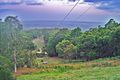
Looking toward Newcastle from the Mount Sugarloaf carpark
-
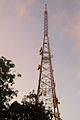
Transmission Tower at Mount Sugarloaf
-
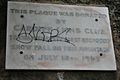
Plaque commemorating the first recorded snowfall on the mountain in 1965
-
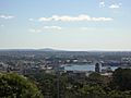
Mount Surgarloaf (just left of centre) as seen from inner city Newcastle
-
View from the top


