
Mount Tate facts for kids

Mount Tate is a famous mountain in Japan. It is part of the Hida Mountains, also known as the North Alps. You can find it in the southeastern part of Toyama Prefecture.
Mount Tate is actually a name for three main peaks:
- Mt.O (3,003 meters high)
- Mt. Onanji (3,015 meters high)
- Fujinooritate (2,999 meters high)
This mountain is a big part of Chūbu-Sangaku National Park. This park was created on December 4, 1934. Mount Tate and Mt. Tsurugi are special because they have real glaciers. These are some of the very few glaciers found in Japan.
Contents
What is Mount Tate Made Of?
Mount Tate is mostly made of strong rocks called granite and gneiss. But there's also a smaller volcano nearby. This volcano is made of andesite and dacite rocks. It sits on a ridge about 2 kilometers (1.2 miles) west of the main peak. This volcano is 2,621 meters (8,599 feet) high. It has erupted a few times in the past, with the last one happening in 1839.
Where is Mount Tate?
Location and How to Get There
Mount Tate is located in the southeast of Toyama Prefecture. The town of Tateyama is at the base of the mountain. You can get to this town by train from Toyama City, which is the capital of the prefecture.
If you want to climb or visit, you can take public transport up to Murodo Plateau Station. This station is very high up, at 2,450 meters (8,038 feet). From there, you can walk to the top of the mountain. The glaciers found in Japan are located here.
Mountains Nearby

Mount Tate is surrounded by other impressive mountains. Here are some of them:
| Image | Mountain | Elevation | Distance and direction from the Top |
Note |
|---|---|---|---|---|
 |
Mt. Tsurugi 剱岳 |
2,999 meters (9,839 feet) | 5.3 kilometers (3.3 miles) North |
One of the 100 Famous Japanese Mountains |
 |
Mt. Bessan 別山 |
2,880 meters (9,449 feet) | 2.4 kilometers (1.5 miles) North |
|
 |
Mt. Tate 立山 |
3,015 meters (9,892 feet) | 0 kilometers (0 miles) | One of the 100 Famous Japanese Mountains The tallest mountain in Toyama Prefecture |
 |
Mt. Ryūō 龍王岳 |
2,872 meters (9,423 feet) | 1.7 kilometers (1.1 miles) Southwest |
|
 |
Mt. Harinoki 針ノ木岳 |
2,820.60 meters (9,254 feet) | 7.2 kilometers (4.5 miles) Southeast |
One of the 200 Japanese Mountains |
 |
Mt. Akaushi 赤牛岳 |
2,864.23 meters (9,397 feet) | 12.8 kilometers (8.0 miles) South |
One of the 200 Japanese Mountains |
 |
Mt. Yakushi 薬師岳 |
2,926.01 meters (9,600 feet) | 13.7 kilometers (8.5 miles) Southwest |
One of the 100 Famous Japanese Mountains |
Rivers from the Mountain
Mount Tate is an important source of water. Several rivers start here and flow all the way to the Sea of Japan.
- Hayatsuki River
- Tsurugisawa, which flows into the Kurobe River
Images for kids
-
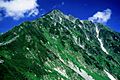
Tateyama from Higashi-Ichinokoshi
-
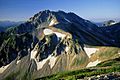
Tateyama from Mount Bessan
-
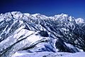
Tateyama and Mount Tsurugi from Mount Jii
-
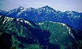
Tateyama and Mount Tsurugi from Mount Asahi


See also
 In Spanish: Monte Tate para niños
