
Mountville, Pennsylvania facts for kids
Quick facts for kids
Mountville, Pennsylvania
|
|
|---|---|
|
Borough
|
|

Mountville Community Center
|
|

Location in Lancaster County, Pennsylvania
|
|

Mountville, Pennsylvania
Location in Pennsylvania

Mountville, Pennsylvania
Location in the United States
|
|
| Country | United States |
| State | Pennsylvania |
| County | Lancaster |
| Area | |
| • Total | 0.86 sq mi (2.23 km2) |
| • Land | 0.86 sq mi (2.23 km2) |
| • Water | 0.00 sq mi (0.00 km2) |
| Elevation | 443 ft (135 m) |
| Population
(2020)
|
|
| • Total | 3,017 |
| • Density | 3,504.07/sq mi (1,353.31/km2) |
| Time zone | UTC-5 (EST) |
| • Summer (DST) | UTC-4 (EDT) |
| ZIP Code |
17554
|
| Area code(s) | 717 |
| FIPS code | 42-52016 |
Mountville is a small town, called a borough, located in Lancaster County, Pennsylvania, in the United States. In 2020, about 3,022 people lived there, which was a bit more than in 2010. Did you know the very first factory for Charles Chips potato chips used to be in Mountville?
Contents
Mountville's Location and Landscape
Mountville is found in the western part of Lancaster County. It's at these coordinates: 40°2′23″N 76°25′57″W / 40.03972°N 76.43250°W.
How to Get Around Mountville
A big four-lane highway, U.S. Route 30, goes through the northern part of Mountville. You can get on or off this highway from College Avenue. If you drive east on US 30 for about 7 miles (11 km), you'll reach Lancaster, which is the main city of the county. If you go west for about 17 miles (27 km), you'll get to York.
Another important road, Pennsylvania Route 462, runs right through the middle of Mountville. It's called Columbia Avenue there. This road takes you east about 6 miles (10 km) to the center of Lancaster, or west about 5 miles (8 km) to Columbia.
Mountville's Size and Waterways
Mountville covers a total area of about 0.86 square miles (2.2 square kilometers). Only a tiny part of this area, about 0.12%, is water.
The eastern side of Mountville has a stream called the West Branch of Little Conestoga Creek. This creek flows south into the Conestoga River, which then joins the big Susquehanna River. On the western side of Mountville, there's another stream called Strickler Run. This stream flows west and goes directly into the Susquehanna River.
Who Lives in Mountville?
| Historical population | |||
|---|---|---|---|
| Census | Pop. | %± | |
| 1860 | 325 | — | |
| 1870 | 430 | 32.3% | |
| 1910 | 803 | — | |
| 1920 | 757 | −5.7% | |
| 1930 | 954 | 26.0% | |
| 1940 | 967 | 1.4% | |
| 1950 | 1,064 | 10.0% | |
| 1960 | 1,411 | 32.6% | |
| 1970 | 1,454 | 3.0% | |
| 1980 | 1,505 | 3.5% | |
| 1990 | 1,977 | 31.4% | |
| 2000 | 2,444 | 23.6% | |
| 2010 | 2,802 | 14.6% | |
| 2020 | 3,022 | 7.9% | |
| 2021 (est.) | 3,006 | 7.3% | |
| Sources: | |||
In the year 2000, there were 2,444 people living in Mountville. These people lived in 1,018 homes, and 692 of those were families. The town was quite busy, with about 2,857 people per square mile (1,103 people per square kilometer).
Most of the people living in Mountville were White (95.2%). There were also smaller numbers of African American (1.3%), Asian (1.0%), and people from other races or mixed races. About 2.7% of the population identified as Hispanic or Latino.
Family Life in Mountville
Out of all the homes in Mountville, about 29% had children under 18 living there. More than half (52%) were married couples living together. About 12% of homes had a female head of household without a husband present. Roughly 27% of homes were single individuals, and about 7.5% of those were people aged 65 or older living alone.
The average home had about 2.31 people, and the average family had about 2.76 people.
Age Groups in Mountville
The population of Mountville includes people of all ages. About 21% of the people were under 18 years old. About 8% were young adults aged 18 to 24. The largest group, about 30%, was between 25 and 44 years old. About 25% were between 45 and 64, and about 16% were 65 years or older. The average age in Mountville was 40 years old.
Community Services in Mountville
Mountville has several important services for its residents. The town is protected by the West Hempfield Township Police Department. It also has its own volunteer fire department, which helps keep everyone safe. For education, Mountville is part of the Hempfield School District.
Mountville's Past: A Brief History

Mountville was first planned out on January 11, 1814, by a person named Isaac Rohrer. He divided the land into 130 building lots and sold them by a lottery. The town was originally called "Mount Pleasant." This name was chosen because the town was built on a high spot, offering a beautiful view of the countryside all around. It was located about 4 miles (6 km) east of Columbia, along a main road called the Lancaster and Susquehanna Turnpike.
In 1842, the town got its first post office. However, there was already another town in Pennsylvania named Mount Pleasant. To avoid confusion, the postal service asked for a name change, and that's how "Mountville" came to be.
As the town grew, people realized they needed their own water system. So, in 1906, Mountville officially became a borough. This meant it could govern itself and provide services like water to its residents.
Over the years, Mountville has grown by adding more land around its original borders. Today, it's just under one square mile in size. It has homes, businesses, industrial areas, and public spaces. Mountville is proud to have a lot of public park space for its size, meaning plenty of green areas for its residents to enjoy.
Images for kids
-
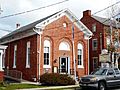
Borough Hall
-
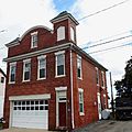
1907 firehouse
-
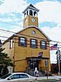
VFW building


See also
 In Spanish: Mountville (Pensilvania) para niños
