Moçâmedes facts for kids
Quick facts for kids
Moçâmedes
|
|
|---|---|
|
Municipality
|
|
| Country | |
| Province | Namibe Province |
| Founded | 1840 |
| Area | |
| • Total | 8,916 km2 (3,442 sq mi) |
| Elevation | 9 m (30 ft) |
| Population
(2014)
|
|
| • Total | 292,535 |
| • Density | 32.8101/km2 (84.978/sq mi) |
| Time zone | UTC+1 (WAT) |
| Climate | BWh |
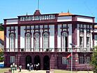
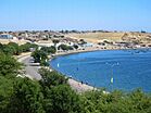
Moçâmedes is a city in southwestern Angola. It is the capital of Namibe Province. In 2014, about 255,000 people lived there. The city was started in 1840 by the Portuguese. From 1985 to 2016, it was called Namibe. Moçâmedes has a cool, dry climate. It is close to the Namib Desert, so it has desert plants.
Contents
History of Moçâmedes
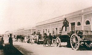
Portuguese explorers first visited this area in 1785. A man named Luís Cândido Cordeiro Pinheiro Furtado claimed it for Portugal. He was sent by the governor-general of Angola, Baron Moçâmedes. The bay was named Moçâmedes to honor the baron.
In 1839, another governor, Admiral Noronha, sent a group to make local leaders loyal to Portugal.
Founding the City
Moçâmedes was officially founded in 1840. The Portuguese government ordered it to be built. They chose a bay that was first called Angra do Negro.
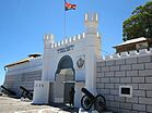
In 1840, a factory was built. A fort was also built at Ponta Negra. People from Madeira (a Portuguese island) and Brazil came to live here. In the 1850s, many German settlers also moved to the city. The Portuguese government helped them travel and settle.
Growth as a Fishing Port
The village grew into an important fishing port. By the 1960s, it had 143 fishing boats. There were also many factories that processed fish. Moçâmedes became one of the top fishing ports in Angola. Other important ports were Luanda, Benguela, and Lobito.
Iona National Park
About 200 kilometers from Moçâmedes, the Portuguese created Iona National Park. This is Angola's oldest and largest national park. It was made a protected area in 1937. In 1964, it became a national park. It covers a huge area of 15,150 square kilometers.
Climate and Weather
Moçâmedes has a hot desert climate. This means it is very dry and hot. Even though it is north of the Tropic of Capricorn, it stays cool. This is because of the Benguela Current in the Atlantic Ocean. This cool ocean current makes July and August cooler than 18 degrees Celsius.
| Climate data for Namibe | |||||||||||||
|---|---|---|---|---|---|---|---|---|---|---|---|---|---|
| Month | Jan | Feb | Mar | Apr | May | Jun | Jul | Aug | Sep | Oct | Nov | Dec | Year |
| Record high °C (°F) | 34.8 (94.6) |
34.2 (93.6) |
37.4 (99.3) |
38.9 (102.0) |
40.3 (104.5) |
38.5 (101.3) |
36.7 (98.1) |
27.3 (81.1) |
30.0 (86.0) |
30.0 (86.0) |
33.7 (92.7) |
31.7 (89.1) |
40.3 (104.5) |
| Mean daily maximum °C (°F) | 27.0 (80.6) |
28.0 (82.4) |
28.9 (84.0) |
27.9 (82.2) |
25.8 (78.4) |
22.4 (72.3) |
20.6 (69.1) |
20.9 (69.6) |
22.4 (72.3) |
23.6 (74.5) |
25.3 (77.5) |
25.9 (78.6) |
24.9 (76.8) |
| Daily mean °C (°F) | 23.0 (73.4) |
24.7 (76.5) |
25.6 (78.1) |
24.2 (75.6) |
21.1 (70.0) |
18.3 (64.9) |
17.4 (63.3) |
17.9 (64.2) |
19.2 (66.6) |
20.4 (68.7) |
21.9 (71.4) |
22.5 (72.5) |
21.4 (70.5) |
| Mean daily minimum °C (°F) | 19.1 (66.4) |
19.8 (67.6) |
20.7 (69.3) |
18.7 (65.7) |
14.7 (58.5) |
12.8 (55.0) |
13.0 (55.4) |
13.8 (56.8) |
14.9 (58.8) |
15.9 (60.6) |
17.1 (62.8) |
17.7 (63.9) |
16.5 (61.7) |
| Record low °C (°F) | 13.0 (55.4) |
12.1 (53.8) |
12.6 (54.7) |
10.2 (50.4) |
7.4 (45.3) |
4.5 (40.1) |
6.5 (43.7) |
5.2 (41.4) |
7.2 (45.0) |
8.2 (46.8) |
10.5 (50.9) |
11.2 (52.2) |
4.5 (40.1) |
| Average precipitation mm (inches) | 7.2 (0.28) |
10.0 (0.39) |
17.1 (0.67) |
9.7 (0.38) |
0.1 (0.00) |
0.1 (0.00) |
0.2 (0.01) |
0.2 (0.01) |
0.3 (0.01) |
1.1 (0.04) |
2.1 (0.08) |
2.9 (0.11) |
51.0 (2.01) |
| Average precipitation days (≥ 0.1 mm) | 2 | 2 | 3 | 2 | 0 | 0 | 0 | 1 | 0 | 1 | 1 | 1 | 13 |
| Average relative humidity (%) | 80 | 79 | 78 | 79 | 82 | 84 | 84 | 85 | 84 | 83 | 80 | 79 | 81 |
| Mean monthly sunshine hours | 210.8 | 209.1 | 232.5 | 231.0 | 217.0 | 141.0 | 105.4 | 111.6 | 129.0 | 155.0 | 213.0 | 220.1 | 2,175.5 |
| Mean daily sunshine hours | 6.8 | 7.4 | 7.5 | 7.7 | 7.0 | 4.7 | 3.4 | 3.6 | 4.3 | 5.0 | 7.1 | 7.1 | 6.0 |
| Source: Deutscher Wetterdienst | |||||||||||||
Economy and Industry
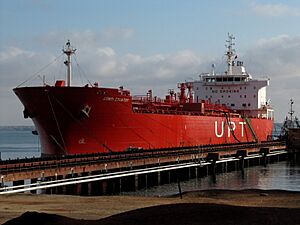
In 1966-67, a large terminal was built at Saco. Saco is a bay 12 kilometers north of Moçâmedes. This terminal was made to ship iron ore from a mine inland at Cassinga.
A German company called Krupp built the mine and a 300-kilometer railway. A Portuguese company, SETH, built the modern harbor terminal. SETH was owned by Højgaard & Schultz from Denmark. Just one year later, in 1967, the first huge ship docked. It carried 250,000 tons of iron ore.
Culture and Fun
Religion
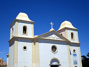
The main church in the city is called Sé Catedral de São Pedro. It is the main church for the Roman Catholic Diocese of Namibe. This area became its own diocese in 2009. It is part of the larger Roman Catholic Archdiocese of Lubango.
Sports
In 2013, Moçâmedes (then called Namibe) and the capital city, Luanda, hosted a big sports event. They held the 2013 FIRS Men's Roller Hockey World Cup. This was the first time a roller hockey World Cup was held in Africa.
Getting Around Moçâmedes
By Train
Moçâmedes is the end point of the Moçâmedes Railway. This train line was first built with narrow tracks. In the 1950s, the tracks were made wider to 1067mm.
By Sea
Moçâmedes has one of Angola's three most important ports. The other major ports are Luanda and Lobito.
By Air
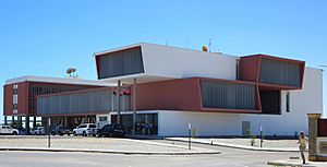
The city is served by the Namibe Airport. This airport is about 7 kilometers south of the city. There is also an older airport, Yuri Gagarin airport, which is closer to the city center. It connects Moçâmedes to other parts of Angola.
Images for kids
See also
 In Spanish: Namibe para niños
 | John T. Biggers |
 | Thomas Blackshear |
 | Mark Bradford |
 | Beverly Buchanan |


