
Muddy Run (Christina River tributary) facts for kids
Quick facts for kids Muddy Run |
|
|---|---|

Muddy Run south of Reybold Road
|
|


|
|
| Other name(s) | Tributary to Christina River |
| Country | United States |
| State | Delaware |
| County | New Castle |
| Physical characteristics | |
| Main source | Persimmon Run divide Pond at Summit View, Delaware 155 ft (47 m) 39°38′30″N 075°46′16″W / 39.64167°N 75.77111°W |
| River mouth | Christina River Heather Woods, Delaware 18 ft (5.5 m) 39°37′54″N 075°41′51″W / 39.63167°N 75.69750°W |
| Length | 6.61 mi (10.64 km) |
| Basin features | |
| Progression | south then northeast |
| River system | Christina River |
| Basin size | 14.95 square miles (38.7 km2) |
| Tributaries |
|
| Waterbodies | Sunset Lake |
| Bridges | I-95, Welsh Tract Road, Smith Way, Old Baltimore Pike, Bartley Drive, Pencader Drive, Galsgow Avenue, DE 896, GBC Drive, DE 72, Salem Church Road |
Muddy Run is a small stream, or narrow river, located in northern New Castle County, Delaware, in the United States. It is about 6.61 miles (10.64 kilometers) long.
Where Does Muddy Run Flow?
Muddy Run begins in New Castle County, Delaware. It starts near the area where Persimmon Run also begins.
The stream first flows south, then it turns and flows towards the northeast. Finally, Muddy Run joins the Christina River in a place called Heather Woods.
Understanding the Muddy Run Watershed
A watershed is an area of land where all the water drains into a single river, lake, or ocean. The Muddy Run watershed covers about 14.95 square miles (38.7 square kilometers).
This area gets about 45.6 inches (116 centimeters) of rain each year. About 23.1% of the land in the Muddy Run watershed is covered by forests. This means a good portion of the land is filled with trees.
Images for kids
-
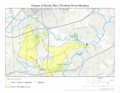
This map shows the path of Muddy Run.
-
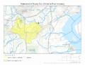
This map shows the entire area that drains into Muddy Run.
.gif)
.gif)
