
Muir Beach, California facts for kids
Quick facts for kids
Muir Beach
|
|
|---|---|

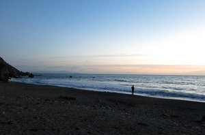
Muir Beach as seen from the beach in December 2013
|
|

Location in Marin County and the state of California
|
|

Muir Beach CDP, California
|
|
| Country | |
| State | |
| County | Marin |
| Government | |
| • Type | Community Services District |
| Area | |
| • Total | 0.493 sq mi (1.28 km2) |
| • Land | 0.493 sq mi (1.28 km2) |
| • Water | 0 sq mi (0 km2) 0% |
| Elevation | 312 ft (95 m) |
| Population
(2020)
|
|
| • Total | 304 |
| • Density | 616.6/sq mi (238.1/km2) |
| Time zone | UTC-8 (Pacific) |
| • Summer (DST) | UTC-7 (PDT) |
| ZIP code |
94965
|
| Area codes | 415/628 |
| FIPS code | 06-49950 |
| GNIS feature IDs | 1853403, 2408888 |
Muir Beach is a small community and beach on the Pacific Ocean. It is located about 16.5 miles (26.6 km) northwest of San Francisco. You can find it in western Marin County, California, United States.
Unlike some other places nearby, Muir Beach is not directly named after the famous nature lover John Muir. Instead, it got its name from the popular Muir Woods National Monument. This was done to help people recognize the area. In 2020, about 304 people lived here. The community sits right next to the beach.
The beach itself is about 1,000 feet (300 m) long and 200 feet (60 m) wide. It has coarse sand and some large rocks. Redwood Creek flows into the ocean at this beach. There is a parking lot and a footbridge to help visitors get to the beach.
This area was once known as Bello Beach. The beach itself was called Big Lagoon. This was because a freshwater lagoon used to be where the parking lot is now. Over time, farming in the 1900s changed how the creek flowed and affected the lagoon.
Contents
Exploring Muir Beach's Geography
Muir Beach is considered a census designated place (CDP). This means it's a community that looks like a town but isn't officially governed as one. The U.S. Census Bureau says the CDP covers about 0.5 square miles (1.3 square kilometers) of land. There is no water area within the CDP.
California State Route 1 is a main road that passes through the area. It can take you northeast about 6 miles (9.7 km) to Sausalito. Or, you can go northwest about 22 miles (35 km) to Point Reyes Station. Muir Beach is known for having one of the cleanest beaches in California.
Who Lives in Muir Beach?
The people living in Muir Beach make up a small, close-knit community. In 2010, there were 310 people living here. Most of the people were White (91.3%). A smaller number were Asian, African American, or Native American. About 2.3% of the people were Hispanic or Latino.
Most people lived in family homes. About 12.3% of the population was under 18 years old. Many residents were adults aged 45 to 64 (44.5%). The average age was around 52.6 years old. This means many older adults live in Muir Beach.
In 2000, there were 295 people. The community has not changed much in size. Most homes were owned by the people living in them.

Learning and Education in Muir Beach
Students in Muir Beach attend public schools in nearby areas. Most of the community is part of the Mill Valley School District. A small part is in the Bolinas-Stinson Union Elementary School District. All students in Muir Beach attend the Tamalpais Union High School District. They also have access to the Marin Community College District.
Younger students go to Tamalpais Valley Elementary School for kindergarten through 5th grade. Middle schoolers (grades 6-8) attend Mill Valley Middle School. High school students (grades 9-12) go to Tamalpais High School.
Muir Beach's Climate and Weather
Muir Beach has a type of weather called a "warm-summer Mediterranean climate." This means it has warm, dry summers and mild, wet winters. Like many places along the California coast, summer afternoons can be cool and windy. Sometimes, it can even be foggy because of winds blowing in from the ocean.
The area gets a good amount of rain. On average, it receives about 40.7 inches (1034.7 mm) of rain each year. The rain mostly falls during the winter months. Summers are usually very dry.
| Climate data for Stinson Beach (Bolinas), California | |||||||||||||
|---|---|---|---|---|---|---|---|---|---|---|---|---|---|
| Month | Jan | Feb | Mar | Apr | May | Jun | Jul | Aug | Sep | Oct | Nov | Dec | Year |
| Mean daily maximum °F (°C) | 55.3 (12.9) |
59.6 (15.3) |
63.0 (17.2) |
66.0 (18.9) |
69.5 (20.8) |
73.8 (23.2) |
76.3 (24.6) |
76.7 (24.8) |
76.7 (24.8) |
72.0 (22.2) |
62.6 (17.0) |
55.4 (13.0) |
67.2 (19.6) |
| Mean daily minimum °F (°C) | 42.9 (6.1) |
44.8 (7.1) |
46.1 (7.8) |
47.5 (8.6) |
50.0 (10.0) |
52.7 (11.5) |
54.0 (12.2) |
54.5 (12.5) |
53.8 (12.1) |
51.4 (10.8) |
47.1 (8.4) |
43.1 (6.2) |
49.0 (9.4) |
| Average precipitation inches (mm) | 6.2 (160) |
6.2 (160) |
4.6 (120) |
2.0 (51) |
1.1 (28) |
0.3 (7.6) |
0 (0) |
0.1 (2.5) |
0.3 (7.6) |
1.7 (43) |
4.4 (110) |
6.5 (170) |
33.4 (859.7) |
| Source: Bestplaces.net | |||||||||||||
A Moment in Muir Beach's History
Muir Beach has a unique place in history. On December 11, 1965, it was the location of the Third Acid Test. These were a series of events that combined music, lights, and experimental art. They were important in the counterculture movement of the 1960s.
See also
 In Spanish: Muir Beach para niños
