Mulberry Grove, Illinois facts for kids
Quick facts for kids
Mulberry Grove, Illinois
|
|
|---|---|

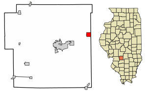
Location of Mulberry Grove in Bond County and Illinois
|
|

Location of Illinois in the United States
|
|
| Country | United States |
| State | Illinois |
| County | Bond |
| Incorporated | 1857 |
| Area | |
| • Total | 1.02 sq mi (2.66 km2) |
| • Land | 1.02 sq mi (2.63 km2) |
| • Water | 0.01 sq mi (0.02 km2) |
| Elevation | 548 ft (167 m) |
| Population
(2020)
|
|
| • Total | 520 |
| • Density | 511.81/sq mi (197.64/km2) |
| Time zone | UTC-6 (CST) |
| • Summer (DST) | UTC-5 (CDT) |
| ZIP Code(s) |
62262
|
| Area code(s) | 618 |
| FIPS code | 17-51284 |
| GNIS feature ID | 2399424 |
| Wikimedia Commons | Mulberry Grove, Illinois |
| Website | https://mulberrygroveil.org/ |
Mulberry Grove is a small village located in the eastern part of Bond County, Illinois, in the United States. In 2020, about 520 people lived here. It's a quiet place with a rich history.
Contents
History of Mulberry Grove
Mulberry Grove has had a few different names over the years, including Bucktown, Houston, and Shakerag. A post office was first opened here in 1834. The village officially became an incorporated village in 1857. This means it gained its own local government.
Geography and Location
Mulberry Grove is easy to find! It sits along Illinois Route 140, which is a main road. It's also about one mile north of I-70, a major interstate highway.
Nearby Towns and Waterways
To the west, about seven miles away, is the town of Greenville. To the east, about nine miles away, is Vandalia. A stream called Owl Creek flows along the north side of the village. This creek eventually joins Hurricane Creek a little further east.
Size of the Village
According to information from 2021, Mulberry Grove covers a total area of about 1.03 square miles (2.66 square kilometers). Most of this area, about 1.02 square miles (2.63 square kilometers), is land. A very small part, about 0.01 square miles (0.02 square kilometers), is water.
Population Changes Over Time
The number of people living in Mulberry Grove has changed quite a bit over the years. Here's a look at the population from 1900 to 2020:
| Historical population | |||
|---|---|---|---|
| Census | Pop. | %± | |
| 1900 | 632 | — | |
| 1910 | 716 | 13.3% | |
| 1920 | 725 | 1.3% | |
| 1930 | 596 | −17.8% | |
| 1940 | 702 | 17.8% | |
| 1950 | 712 | 1.4% | |
| 1960 | 745 | 4.6% | |
| 1970 | 697 | −6.4% | |
| 1980 | 707 | 1.4% | |
| 1990 | 660 | −6.6% | |
| 2000 | 671 | 1.7% | |
| 2010 | 634 | −5.5% | |
| 2020 | 520 | −18.0% | |
| U.S. Decennial Census | |||
Recent Population Details (2020)
In 2020, the village had 520 residents. There were 344 homes, and 175 of these were families. The village had about 507 people per square mile.
About 29.1% of the homes had children under 18 living in them. Many homes, 40.7%, were married couples. The average household had about 3.46 people.
The median age in the village was 35.2 years old. This means half the people were younger and half were older than 35.2. About 26.9% of the population was under 18.
See also
 In Spanish: Mulberry Grove (Illinois) para niños

