Mule Keys facts for kids

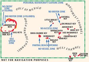
The Mule Keys are a group of small islands in the Florida Keys, located in Monroe County, Florida, United States. They are found about 3 to 12 miles west of Key West. A channel called the Northwest Channel separates them from Key West. To their west, the 6-mile wide Boca Grande Channel separates them from the Marquesas Keys. These islands are part of the outer islands of the Florida Keys.
The Mule Keys are an area managed by Monroe County. They are also part of the Key West National Wildlife Refuge, which protects nature. The total area of these islands is about 1.07 square miles. Most of this is land (1.02 square miles), with a small part being inland water, like small ponds, on three of the keys. Most of the islands are empty. Only Mule Key had two people living on it in 2000, likely park rangers or Coast Guard members.
The U.S. Government has set most of this area aside as part of the Key West National Wildlife Refuge. This means it's a protected zone. For example, you are not allowed to anchor your boat in the sand near Man Key and Woman Key. Even though Woman Key used to be a popular spot for people visiting from Key West, it's now restricted. Boca Grande Key is still a popular place to visit. However, anchoring is only allowed off its northwest side, not the south.
One of the islands, Ballast Key, is privately owned. In July 2011, it was for sale for $13,800,000.
The easternmost island, Mule Key, is about 2.7 miles west of Sunset Key, which is part of Key West city. The largest and westernmost island, Boca Grande Key, is 6 miles (10 km) east of the Marquesas Keys.
The Islands of Mule Keys
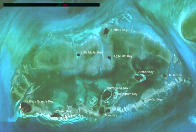
Detailed maps show that there are 12 individual islands in the Mule Keys group. Here is a list of them:
| Island ID Nr.1) |
Islet | Land Area (m2) |
Inland Waters (m2) |
Total Area (m2) |
Coordinates | Comment |
|---|---|---|---|---|---|---|
| 3031 | Mule Key | 52169 | - | 52169 | 24°33′43.2″N 81°51′42.4″W / 24.562000°N 81.861778°W | easternmost |
| 3032 | Archer Key | 247136 | - | 247136 | 24°33′43.2″N 81°53′23.3″W / 24.562000°N 81.889806°W | actually two separate islets |
| 3033 | Crawfish Key | 17125 | - | 17125 | 24°32′19.4″N 81°53′01.6″W / 24.538722°N 81.883778°W | |
| 3034 | Barracouta Key2) | 482627 | 57221 | 539848 | 24°32′38.5″N 81°55′17.5″W / 24.544028°N 81.921528°W | including tiny islet 430 m south |
| Joe Ingram Key2) | - | 24°32′43.9″N 81°54′45.4″W / 24.545528°N 81.912611°W | smallest | |||
| 3035 | Man Key | 358808 | - | 358808 | 24°31′40.3″N 81°55′38.5″W / 24.527861°N 81.927361°W | actually three separate islets |
| 3036 | Ballast Key | 46801 | 4741 | 51542 | 24°31′23.0″N 81°57′51.1″W / 24.523056°N 81.964194°W | southernmost |
| 3037 | Woman Key | 317669 | - | 317669 | 24°31′27.6″N 81°58′25.4″W / 24.524333°N 81.973722°W | |
| 3038 | Boca Grande Key | 741228 | 80416 | 821644 | 24°32′04.4″N 82°00′18.3″W / 24.534556°N 82.005083°W | largest, westernmost |
| 3039 | Little Mullet Key | 58625 | - | 58625 | 24°34′53.8″N 81°57′01.9″W / 24.581611°N 81.950528°W | |
| 3040 | Big Mullet Key | 87211 | - | 87211 | 24°34′44.5″N 81°55′08.0″W / 24.579028°N 81.918889°W | |
| 3041 | Cottrell Key | 215943 | - | 215943 | 24°36′12.9″N 81°55′17.7″W / 24.603583°N 81.921583°W | northernmost |
| Mule Keys | 2625342 | 142378 | 2767720 | |||
| 1) This number helps track areas for official counts, like a census.
2) Barracouta Key and Joe Ingram Key are counted together, so their exact separate sizes are not known. Joe Ingram Key is thought to be about 10,000 square meters. |
||||||
How the Keys Look on Maps
When you look at nautical maps, the Mule Keys appear like a ring-shaped island group, similar to an atoll. They stretch about 11 miles from east to west and 6 miles from north to south. This covers a sea area of about 58 square miles. The islands of Mule Key, Crawfish Key, Man Key, Ballast Key, Woman Key, and Boca Grande Key form the southern edge of this ring. Cottrell Key is located in the north.
Underwater Reefs Nearby
About 7 miles south of Mule Key, across the West Channel, there are three important underwater reefs. These are:
- Eastern Dry Rocks, located at 24°27′42.6″N 81°50′38.1″W / 24.461833°N 81.843917°W
- Rock Key, located at 24°27′21.3″N 81°51′26.3″W / 24.455917°N 81.857306°W
- Sand Key, located at 24°27′18.3″N 81°52′37.5″W / 24.455083°N 81.877083°W
 | DeHart Hubbard |
 | Wilma Rudolph |
 | Jesse Owens |
 | Jackie Joyner-Kersee |
 | Major Taylor |


