Mullaghmore, County Londonderry facts for kids
Quick facts for kids Mullaghmore |
|
|---|---|
| an Mullach Mór | |
 |
|
| Highest point | |
| Elevation | 550 m (1,800 ft) |
| Prominence | 235 m (771 ft) |
| Listing | Marilyn |
| Geography | |
| Location | County Londonderry, Northern Ireland |
| Parent range | Sperrin Mountains |
| OSI/OSNI grid | C739008 |
| Topo map | OSNI Discoverer Series 8 (1:50000) |
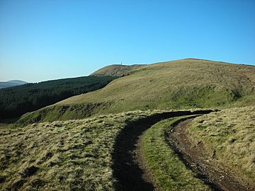
Mullaghmore is a cool mountain located in County Londonderry, Northern Ireland. Its name comes from the Irish words an Mullach Mór, which means "the big summit." It's part of the beautiful Sperrin Mountains range. This mountain stands tall at 550 meters (about 1,804 feet) above sea level.
Mullaghmore is known for its interesting summit. You'll find a large telecommunication tower right at the top. This tower helps with phone signals and other communications across the area. The mountain is about 5 miles north of Draperstown village and 6 miles south of Dungiven. Locals sometimes call it "The Birren," which is why the road crossing it is named "Birren Road."
Contents
Exploring Mullaghmore
Mullaghmore is a great place to explore the outdoors. It offers amazing views of the surrounding countryside. Even though it's not the highest mountain in Ireland, it's still a significant peak. It's the 359th highest point on the entire island of Ireland.
What is a Marilyn?
Mullaghmore is listed as a "Marilyn." This isn't a person's name! In the world of mountains, a Marilyn is a hill or mountain that is at least 150 meters (about 492 feet) high. It must also have a "prominence" of at least 150 meters. Prominence means how much a mountain sticks up from the land around it. Think of it as how tall it is compared to the lowest point connecting it to a higher peak. Mullaghmore's prominence is 235 meters, making it a true Marilyn.
The Sperrin Mountains
Mullaghmore is part of the Sperrin Mountains. This is one of the largest mountain ranges in Northern Ireland. The Sperrins are famous for their wild, untouched landscapes. They have rolling hills, deep valleys, and sparkling rivers. The area is perfect for hiking, cycling, and enjoying nature. You can often spot different types of wildlife here.
Nature and Wildlife
The Sperrin Mountains, including Mullaghmore, are home to various plants and animals. You might see birds like the red grouse or hen harrier flying overhead. The landscape is mostly covered in heather and peat bogs. These habitats support unique insects and small mammals. It's a great place to learn about Northern Ireland's natural environment.
Local History and Culture
The area around Mullaghmore has a rich history. People have lived in the Sperrins for thousands of years. You can find ancient monuments like stone circles and burial sites. These tell stories of early settlers. The local communities in places like Draperstown and Dungiven have strong traditions. They often share stories about the mountains and their history.
Visiting Mullaghmore
If you enjoy outdoor adventures, Mullaghmore is a good spot. The "Birren Road" goes over the mountain, making it accessible. While there isn't a marked hiking trail to the very top, experienced hikers can find their way. Remember to always be prepared for changing weather conditions when exploring mountains.
Safety Tips for Hikers
- Always tell someone where you are going and when you expect to be back.
- Wear appropriate clothing and sturdy hiking boots.
- Carry enough water and snacks.
- Bring a map and compass, or a reliable GPS device.
- Check the weather forecast before you go.
- Be aware of your surroundings and respect nature.
Mullaghmore might not be as famous as some other mountains, but it's an important part of Northern Ireland's landscape. It offers a chance to connect with nature and enjoy stunning views.
 | John T. Biggers |
 | Thomas Blackshear |
 | Mark Bradford |
 | Beverly Buchanan |

