Mullingar, Western Australia facts for kids
Quick facts for kids MullingarKalgoorlie–Boulder, Western Australia |
|||||||||||||||
|---|---|---|---|---|---|---|---|---|---|---|---|---|---|---|---|

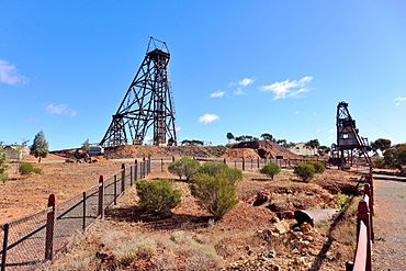
The Hannans North Tourist Mine, a local attraction in Mullingar
|
|||||||||||||||
| Postcode(s) | 6430 | ||||||||||||||
| Area | [convert: needs a number] | ||||||||||||||
| LGA(s) | City of Kalgoorlie–Boulder | ||||||||||||||
| State electorate(s) | Kalgoorlie | ||||||||||||||
| Federal Division(s) | O'Connor | ||||||||||||||
|
|||||||||||||||
Mullingar is a small area, or "locality," in the Eastern Goldfields part of Western Australia. It's a suburb of the bigger city of Kalgoorlie–Boulder. In 2016, about 305 people lived in Mullingar. This was a bit less than the 343 people who lived there in 2011.
Contents
Exploring Mullingar's Location
Mullingar has a unique "wedge" shape. Its northern edge is about 10 kilometers (6 miles) north of the main Kalgoorlie town center. The western side follows a railway line that goes towards Leonora. The eastern side runs alongside Yarri Road.
Most of Mullingar is open bushland. Only a small part of it has houses. This residential area is south of the Goldfields Highway. It sits next to the suburbs of Lamington and Piccadilly, separated by the railway. Some southern areas of Mullingar are used for mining.
Mullingar's Past: A Brief History
People started using the name Mullingar for this area very early, soon after Kalgoorlie was founded. It was probably named after a town called Mullingar in Ireland.
In 1897, a British politician named Henry Charles Richards even visited a nice home in Mullingar. An early count in 1898 showed 110 people living there. By 1901, the population grew to 387. In 1934, a newspaper reporter noticed something interesting. Many houses in Mullingar had survived tough times in the 1920s. This was different from nearby suburbs where many homes had been taken apart.
Fun Things to See in Mullingar
Mullingar is home to some exciting attractions!
Kalgoorlie Speedway
The Kalgoorlie Speedway has been in Mullingar since 1992. It's a place where people race cars on a special track. You can find it on the Goldfields Highway, about 3.5 kilometers (2.2 miles) north of the main housing area.
Hannans North Tourist Mine
In the southern part of Mullingar, you can visit the Hannans North Tourist Mine. This place opened in 1991. It shows visitors how mining was done a long time ago. It's a great way to learn about the history of gold mining in the area.
The Australian Prospectors & Miners' Hall of Fame was also once located at the Hannans North site. It was there from 2001 to 2011. It closed because of money problems.
 | Frances Mary Albrier |
 | Whitney Young |
 | Muhammad Ali |

