Munglinup, Western Australia facts for kids
Quick facts for kids MunglinupWestern Australia |
|
|---|---|

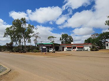
The Munglinup Roadhouse in January 2024
|
|
| Established | 1962 |
| Gazetted | 1962 |
| Postcode(s) | 6450 |
| Elevation | 87 m (285 ft) |
| Area | [convert: needs a number] |
| Location | |
| LGA(s) | Shire of Ravensthorpe |
| State electorate(s) | Roe |
| Federal Division(s) | O'Connor |
Munglinup is a small town in Western Australia. It is located in the Shire of Ravensthorpe. This area is part of the Goldfields–Esperance region.
Contents
Exploring Munglinup's Location
Munglinup is found along the South Coast Highway. This road connects the towns of Ravensthorpe and Esperance. The town is also very close to the Munglinup River.
The Munglinup River
The Munglinup River is important to the area. For most of its path, it forms a natural border. This border is between the Esperance and Ravensthorpe shires.
What Munglinup Means
The name Munglinup comes from the Noongar language. It means where young people met their in-laws. This name first appeared on maps in 1868. These maps were made by the Dempster brothers. They were some of the first settlers in the area.
A Look at Munglinup's History
The land around Munglinup was first used for farming in the late 1950s. By the early 1960s, people living there wanted a townsite. They asked for a new town to be created. This town would be located between Esperance and Ravensthorpe.
When Munglinup Became a Town
The area for the town was measured in 1961. Munglinup officially became a town in 1962. This process is called being gazetted.
Farming and Grain in Munglinup
The land around Munglinup is very good for farming. Farmers in this area grow wheat. They also grow other cereal crops.
Grain Receival Site
Munglinup is a special place for farmers. It is a receival site for Cooperative Bulk Handling. This means farmers bring their harvested grain here. It is then stored and prepared for transport.
 | George Robert Carruthers |
 | Patricia Bath |
 | Jan Ernst Matzeliger |
 | Alexander Miles |


