Muskingum River Navigation Historic District facts for kids
Quick facts for kids |
|
|
Muskingum River Navigation Historic District
|
|
 |
|
| Nearest city | Coshocton, Ohio Coshocton, Muskingum, Morgan, Washington counties |
|---|---|
| Area | 6,004 acres (24.30 km2) |
| Built | 1816 |
| Architect | Bates, David,; Curtis, Samuel, et al. |
| Architectural style | stenwheeler |
| NRHP reference No. | 07000025 |
| Added to NRHP | February 9, 2007 |
The Muskingum River Navigation Historic District is a really special place in Ohio. It covers a huge area of about 6,004 acres (24.30 km2) across four counties: Coshocton, Morgan, Muskingum, and Washington. This district was added to the National Register of Historic Places in 2007.
It's important because it protects old buildings, structures, and sites that tell the story of how people used the Muskingum River for travel and trade long ago.
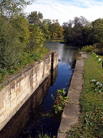
This historic district is all about the amazing system of locks and dams on the Muskingum River. These structures helped boats travel easily along the river. They allowed boats to move between different water levels.
What Makes It Historic?
The Muskingum River lock system is super unique. It was the very first "Navigation Historic District" in the entire United States! This special title was given by the National Park Service. It means the system is recognized for its important role in American history and engineering.
When something is listed as a historic district, it includes many old parts. This district has 12 important buildings and 32 important structures. It also has one important site. These pieces all work together to show how the river was used for navigation.
A Special Waterway
Today, the Muskingum River is still a beautiful place. The historic district is crossed by the Muskingum River Water Trail. This trail is a great way for people to explore the river. You can paddle or boat along the water and see the historic locks and dams up close. It's like traveling back in time!
 | Janet Taylor Pickett |
 | Synthia Saint James |
 | Howardena Pindell |
 | Faith Ringgold |


