Musselshell, Montana facts for kids
Quick facts for kids
Musselshell, Montana
|
|
|---|---|

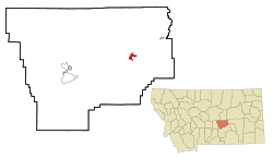
Location in Musselshell County and the state of Montana
|
|
| Country | United States |
| State | Montana |
| County | Musselshell |
| Area | |
| • Total | 2.55 sq mi (6.61 km2) |
| • Land | 2.55 sq mi (6.61 km2) |
| • Water | 0.00 sq mi (0.00 km2) |
| Elevation | 2,995 ft (913 m) |
| Population
(2020)
|
|
| • Total | 59 |
| • Density | 23.13/sq mi (8.93/km2) |
| Time zone | UTC-7 (Mountain (MST)) |
| • Summer (DST) | UTC-6 (MDT) |
| ZIP code |
59059
|
| Area code(s) | 406 |
| FIPS code | 30-52600 |
| GNIS feature ID | 0774524 |
Musselshell is a small community in Musselshell County, Montana, United States. It is known as a census-designated place (CDP). This means it's an area identified by the government for statistics, but it doesn't have its own local government. In 2020, about 59 people lived in Musselshell. The village is located close to the Musselshell River.
Contents
History of Musselshell
The area where Musselshell is located has a long history.
Early Trading Post
In 1866, a company called the Rocky Mountain Wagon Road Company built a trading post here. They named this early settlement "Kerchival City." However, this first post was destroyed by floods.
Renaming to Musselshell
Later, another company, the Montana Hide and Fur Company, built a new post. They also added a warehouse on the same spot. This new settlement was then renamed Musselshell.
Geography of Musselshell
Musselshell is found in the eastern part of Musselshell County. It has some interesting natural features.
Location and Nearby Towns
The community is just south of U.S. Route 12, a major road. Roundup, which is the main town of the county, is about 23 miles (37 km) to the west. Another town, Melstone, is about 12 miles (19 km) to the northeast. Montana Secondary Highway 310 runs through the middle of Musselshell. This road goes southeast for about 40 miles (64 km) to Custer and Interstate 94.
Rivers and Creeks
The Musselshell River flows along the northern edge of the community. This river flows east and eventually joins the larger Missouri River. A smaller stream called Hawk Creek runs along the western side of Musselshell. The total land area of Musselshell is about 2.55 square miles (6.61 square kilometers).
Population of Musselshell
The number of people living in Musselshell has stayed fairly steady over the years.
| Historical population | |||
|---|---|---|---|
| Census | Pop. | %± | |
| 2000 | 60 | — | |
| 2010 | 60 | 0.0% | |
| 2020 | 59 | −1.7% | |
| U.S. Decennial Census | |||
In 2000, there were 60 people living in Musselshell. These people lived in 28 different homes. Most of the people living there were White.
Age Groups
The population in 2000 included people of all ages.
- About 16.7% were under 18 years old.
- About 25.0% were between 25 and 44 years old.
- Another 25.0% were between 45 and 64 years old.
- About 33.3% were 65 years old or older.
The average age of people in Musselshell was 50 years.
Local Media
Musselshell has a local newspaper that keeps residents informed.
The local newspaper is called the Roundup Record-Tribune. It is published every week. This newspaper serves Musselshell County and the areas nearby.
See also
 In Spanish: Musselshell (Montana) para niños

